Zygovisti
Zygovisti
Ζυγοβίστι | |
|---|---|
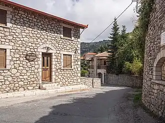 The main street of the village, leading to the square | |
 Zygovisti | |
| Coordinates: 37°35′15″N 22°04′05″E / 37.58750°N 22.06806°E | |
| Country | Greece |
| Administrative region | Peloponnese |
| Regional unit | Arcadia |
| Municipality | Gortynia |
| Municipal unit | Dimitsana |
| Area | |
• Community | 14.98 km2 (5.78 sq mi) |
| Elevation | 1,160 m (3,810 ft) |
| Population (2021)[1] | |
• Community | 27 |
| • Density | 1.8/km2 (4.7/sq mi) |
| Time zone | UTC+2 (EET) |
| • Summer (DST) | UTC+3 (EEST) |
| Vehicle registration | TP |
Zygovisti (Greek: Ζυγοβίστι, also Ζιγοβίστι Zigovisti) is a village in the municipal unit Dimitsana, western Arcadia, Greece. It is located in the mountains east of the river Lousios, 3 km southeast of Dimitsana and 4 km north of Stemnitsa. At 1160 m elevation, it is one of the highest villages in Greece. There is a large marble book in the village square, commemorating the Greek War of Independence.[2] It is considered a traditional settlement.
Historical population
| Year | Population |
|---|---|
| 1981 | 154 |
| 1991 | 131 |
| 2001 | 142 |
| 2011 | 79 |
| 2021 | 27 |
See also
References
- ^ "Αποτελέσματα Απογραφής Πληθυσμού - Κατοικιών 2021, Μόνιμος Πληθυσμός κατά οικισμό" [Results of the 2021 Population - Housing Census, Permanent population by settlement] (in Greek). Hellenic Statistical Authority. 29 March 2024.
- ^ Zygovisti monument Archived 2004-12-10 at the Wayback Machine (in Greek)