Černá u Bohdanče
Černá u Bohdanče | |
|---|---|
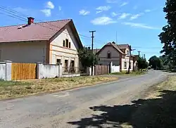 Western part of the village | |
 Flag  Coat of arms | |
 Černá u Bohdanče Location in the Czech Republic | |
| Coordinates: 50°3′22″N 15°40′19″E / 50.05611°N 15.67194°E | |
| Country | |
| Region | Pardubice |
| District | Pardubice |
| First mentioned | 1377 |
| Area | |
• Total | 2.65 km2 (1.02 sq mi) |
| Elevation | 213 m (699 ft) |
| Population (2025-01-01)[1] | |
• Total | 710 |
| • Density | 270/km2 (690/sq mi) |
| Time zone | UTC+1 (CET) |
| • Summer (DST) | UTC+2 (CEST) |
| Postal code | 533 41 |
| Website | www |
Černá u Bohdanče (German: Czerna bei Bohdanetsch) is a municipality and village in Pardubice District in the Pardubice Region of the Czech Republic. It has about 700 inhabitants.
Demographics
| Year | Pop. | ±% |
|---|---|---|
| 1869 | 261 | — |
| 1880 | 262 | +0.4% |
| 1890 | 271 | +3.4% |
| 1900 | 251 | −7.4% |
| 1910 | 243 | −3.2% |
| 1921 | 236 | −2.9% |
| 1930 | 236 | +0.0% |
| 1950 | 194 | −17.8% |
| 1961 | 201 | +3.6% |
| 1970 | 211 | +5.0% |
| 1980 | 217 | +2.8% |
| 1991 | 224 | +3.2% |
| 2001 | 256 | +14.3% |
| 2011 | 341 | +33.2% |
| 2021 | 688 | +101.8% |
| Source: Censuses[2][3] | ||
References
- ^ "Population of Municipalities – 1 January 2025". Czech Statistical Office. 2025-05-16.
- ^ "Historický lexikon obcí České republiky 1869–2011" (in Czech). Czech Statistical Office. 2015-12-21.
- ^ "Population Census 2021: Population by sex". Public Database. Czech Statistical Office. 2021-03-27.
External links
Wikimedia Commons has media related to Černá u Bohdanče.