Alberta Highway 38
 Highway 38 | ||||
|---|---|---|---|---|
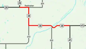 Highway 38 highlighted in red | ||||
| Route information | ||||
| Maintained by the Ministry of Transportation and Economic Corridors | ||||
| Length | 25.9 km[1] (16.1 mi) | |||
| Major junctions | ||||
| West end | ||||
| East end | ||||
| Location | ||||
| Country | Canada | |||
| Province | Alberta | |||
| Specialized and rural municipalities | Sturgeon County, Strathcona County, Lamont County | |||
| Towns | Redwater | |||
| Highway system | ||||
|
| ||||
| ||||
Alberta Provincial Highway No. 38, commonly referred to as Highway 38, is a 25 km (16 mi) east–west highway in central Alberta, Canada. It extends from Highway 28 in Redwater to a 'T' junction with Highway 45 north of Bruderheim.[2][1]
Major intersections
From west to east:
| Rural/specialized municipality | Location | km[1] | mi | Destinations | Notes |
|---|---|---|---|---|---|
| Redwater | 0.0 | 0.0 | Highway 38 western terminus | ||
| 4.3 | 2.7 | ||||
| Sturgeon County | | 10.8 | 6.7 | ||
| ↑ / ↓ | | 19.1 | 11.9 | Vinca Bridge across North Saskatchewan River | |
| Strathcona County | | 19.4 | 12.1 | ||
| Lamont County | | 25.9 | 16.1 | Highway 38 eastern terminus; continues as Highway 45 east | |
| 1.000 mi = 1.609 km; 1.000 km = 0.621 mi | |||||
References
- ^ a b c "Highway 38 in Alberta" (Map). Google Maps. Retrieved March 5, 2018.
- ^ "2015 Provincial Highway 1-216 Progress Chart" (PDF). Alberta Transportation. March 2015. Archived (PDF) from the original on April 10, 2016. Retrieved October 12, 2016.