Alberta Highway 42
 Highway 42 | ||||
|---|---|---|---|---|
 Highway 42 highlighted in red | ||||
| Route information | ||||
| Maintained by the Ministry of Transportation and Economic Corridors | ||||
| Length | 44.02 km[1] (27.35 mi) | |||
| Major junctions | ||||
| West end | ||||
| East end | ||||
| Location | ||||
| Country | Canada | |||
| Province | Alberta | |||
| Specialized and rural municipalities | Red Deer County | |||
| Towns | Penhold | |||
| Highway system | ||||
|
| ||||
| ||||
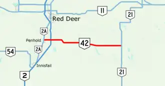
Alberta Provincial Highway No. 42, commonly referred to as Highway 42, is a 44-kilometre (27 mi) highway in central Alberta, Canada that connects Highway 2A in Penhold, about 9 kilometres (6 mi) south of the city of Red Deer, to Highway 21 near the Hamlet of Lousana.[2][1]
Major intersections
From west to east.
| Rural/specialized municipality | Location | km[2] | mi | Destinations | Notes |
|---|---|---|---|---|---|
| Penhold | 0.0 | 0.0 | Access to Red Deer Regional Airport; Highway 42 western terminus; continues as Highway 592 | ||
| Red Deer County | | 4.0 | 2.5 | Interchange; Highway 2 exit 384 | |
| 25.9 | 16.1 | West end of Highway 816 concurrency | |||
| Pine Lake | 27.6 | 17.1 | East end of Highway 816 concurrency | ||
| | 44.0 | 27.3 | UAR 90 east – Lousana | Highway 42 eastern terminus; continues as Urban Approach Road 90 | |
1.000 mi = 1.609 km; 1.000 km = 0.621 mi
| |||||
Template:Attached KML/Alberta Highway 42
KML is not from Wikidata
References
- ^ a b "2015 Provincial Highway 1-216 Progress Chart" (PDF). Alberta Transportation. March 2015. Archived (PDF) from the original on April 10, 2016. Retrieved October 12, 2016.
- ^ a b "Highway 42 in Alberta" (Map). Google Maps. Retrieved February 2, 2018.