Alberta Highway 61
 Highway 61 | ||||
|---|---|---|---|---|
| Red Coat Trail | ||||
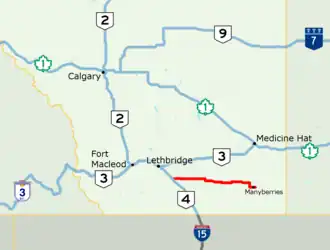 Highway 61 highlighted in red | ||||
| Route information | ||||
| Maintained by the Ministry of Transportation and Economic Corridors | ||||
| Length | 146.8 km[1] (91.2 mi) | |||
| Existed | 1960[2]–present | |||
| Major junctions | ||||
| West end | ||||
| East end | ||||
| Location | ||||
| Country | Canada | |||
| Province | Alberta | |||
| Specialized and rural municipalities | Warner No. 5 County, Forty Mile No. 8 County | |||
| Villages | Foremost | |||
| Highway system | ||||
|
| ||||
| ||||
Alberta Provincial Highway No. 61, commonly referred to as Highway 61, is an east–west highway in southern Alberta, Canada. In the west, Highway 61 starts at Highway 4 north of the Village of Stirling and ends at Highway 889 east of the Hamlet of Manyberries. It is part of the Red Coat Trail, a historical route north of the Canada–US border. The Red Coat Trail continues to Saskatchewan via Highway 889 and Highway 501.[3][1]
History
In 1959, Alberta announced $100,000 of improvements to the highway, and incorporation of it to the provincial highway system the following year.[2] Paving was completed by 1961.[2]
Major intersections
From west to east:
| Rural/specialized municipality | Location | km[1] | mi | Destinations | Notes |
|---|---|---|---|---|---|
| County of Warner No. 5 | Stirling | 0.0 | 0.0 | Red Coat Trail follows Highway 4 north | |
| Wrentham | 23.5 | 14.6 | |||
| County of Forty Mile No. 8 | | 52.2 | 32.4 | West end of Highway 877 concurrency | |
| Skiff | 55.2 | 34.3 | East end of Highway 877 concurrency | ||
| Foremost | 81.1 | 50.4 | West end of Highway 879 concurrency | ||
| 82.7 | 51.4 | East end of Highway 879 concurrency | |||
| Etzikom | 107.6 | 66.9 | |||
| Orion | 128.8– 129.1 | 80.0– 80.2 | West end of Highway 887 concurrency | ||
| | 135.6– 136.0 | 84.3– 84.5 | East end of Highway 887 concurrency | ||
| Manyberries | 146.8 | 91.2 | Red Coat Trail follows Highway 889 south to Highway 501 | ||
1.000 mi = 1.609 km; 1.000 km = 0.621 mi
| |||||
References
Template:Attached KML/Alberta Highway 61
KML is not from Wikidata
- ^ a b c "Highway 61 in southern Alberta" (Map). Google Maps. Retrieved December 20, 2017.
- ^ a b c "Stirling - Manyberries Road Will Be Improved". The Lethbridge Herald. April 25, 1959.
- ^ "2015 Provincial Highway 1-216 Progress Chart" (PDF). Alberta Transportation. March 2015. Archived (PDF) from the original on April 10, 2016. Retrieved October 12, 2016.