Vierlinden
Vierlinden | |
|---|---|
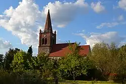 Marxdorf village church | |
Location of Vierlinden within Märkisch-Oderland district 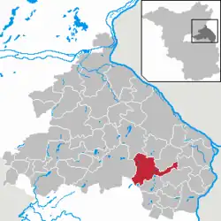 | |
 Vierlinden  Vierlinden | |
| Coordinates: 52°30′54″N 14°18′51″E / 52.51500°N 14.31417°E | |
| Country | Germany |
| State | Brandenburg |
| District | Märkisch-Oderland |
| Municipal assoc. | Seelow-Land |
| Subdivisions | 7 Ortsteile |
| Government | |
| • Mayor (2024–29) | Constantin Schütze[1] (Ind.) |
| Area | |
• Total | 69.45 km2 (26.81 sq mi) |
| Elevation | 46 m (151 ft) |
| Population (2023-12-31)[2] | |
• Total | 1,468 |
| • Density | 21/km2 (55/sq mi) |
| Time zone | UTC+01:00 (CET) |
| • Summer (DST) | UTC+02:00 (CEST) |
| Postal codes | 15306 |
| Dialling codes | 03346 |
| Vehicle registration | MOL |
Vierlinden is a municipality in the district Märkisch-Oderland, in Brandenburg, Germany.
History
The municipality was created on 26 October 2003 after the merging of the municipalities of Diedersdorf, Friedersdorf, Marxdorf and Worin.
Geography
Vierlinden is composed by 7 civil parishes (Ortsteile):
- Alt Rosenthal
- Diedersdorf
- Friedersdorf
- Görlsdorf
- Marxdorf
- Neuentempel
- Worin
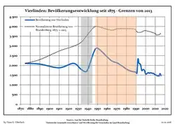
Demography
|
|
References
- ^ Landkreis Märkisch-Oderland Wahl der Bürgermeisterin / des Bürgermeisters. Retrieved 3 July 2024.
- ^ "Bevölkerungsstand im Land Brandenburg Dezember 2023] (Fortgeschriebene amtliche Einwohnerzahlen, basierend auf dem Zensus 2022)". Amt für Statistik Berlin-Brandenburglanguage=German.
- ^ Detailed data sources are to be found in the Wikimedia Commons.Population Projection Brandenburg at Wikimedia Commons
External links
![]() Media related to Vierlinden at Wikimedia Commons
Media related to Vierlinden at Wikimedia Commons
- Official website (in German)