Arivaca Junction, Arizona
Arivaca Junction, Arizona | |
|---|---|
Census Designated Place | |
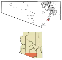 Location of Arivaca Junction in Pima County, Arizona. | |
 Arivaca Junction, Arizona Location of Arivaca Junction in Arizona | |
| Coordinates: 31°44′20″N 111°04′26″W / 31.73889°N 111.07389°W | |
| Country | United States |
| State | Arizona |
| County | Pima |
| Area | |
• Total | 2.95 sq mi (7.65 km2) |
| • Land | 2.95 sq mi (7.65 km2) |
| • Water | 0.00 sq mi (0.00 km2) |
| Elevation | 3,140 ft (957 m) |
| Population (2020) | |
• Total | 970 |
| • Density | 328.37/sq mi (126.79/km2) |
| Time zone | UTC-7 (Mountain (MST)) |
| • Summer (DST) | UTC-7 (MST) |
| Area code | 520 |
| FIPS code | 04-03380 |
| GNIS feature ID | 2582731 |
Arivaca Junction is a census-designated place (CDP) in Pima County, Arizona, United States. The population was 1,090 at the 2010 census. As of July 1, 2015, it had an estimated population of 1,065.[3] Arivaca Junction has an estimated elevation of 3,140 feet (960 m) above sea level.[2]
Demographics
| Census | Pop. | Note | %± |
|---|---|---|---|
| 2010 | 1 | — | |
| 2020 | 970 | 96,900.0% | |
| U.S. Decennial Census[4] | |||
References
- ^ "2020 U.S. Gazetteer Files". United States Census Bureau. Retrieved October 29, 2021.
- ^ a b "Feature Detail Report for: Arivaca Junction". Geographic Names Information System. United States Geological Survey, United States Department of the Interior.
- ^ "Arivaca Junction, AZ Profile: Facts, Map & Data". AZ Hometown Locator. Retrieved January 22, 2016.
- ^ "Census of Population and Housing". Census.gov. Retrieved June 4, 2016.
