Bohuslávky
Bohuslávky | |
|---|---|
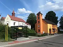 Chapel of All Saints and the municipal office | |
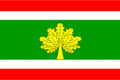 Flag 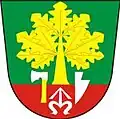 Coat of arms | |
 Bohuslávky Location in the Czech Republic | |
| Coordinates: 49°33′19″N 17°34′4″E / 49.55528°N 17.56778°E | |
| Country | |
| Region | Olomouc |
| District | Přerov |
| First mentioned | 1322 |
| Area | |
• Total | 2.89 km2 (1.12 sq mi) |
| Elevation | 297 m (974 ft) |
| Population (2025-01-01)[1] | |
• Total | 319 |
| • Density | 110/km2 (290/sq mi) |
| Time zone | UTC+1 (CET) |
| • Summer (DST) | UTC+2 (CEST) |
| Postal code | 751 31 |
| Website | www |
Bohuslávky is a municipality and village in Přerov District in the Olomouc Region of the Czech Republic. It has about 300 inhabitants.
Bohuslávky lies approximately 14 kilometres (9 mi) north-east of Přerov, 24 km (15 mi) east of Olomouc, and 234 km (145 mi) east of Prague.
Demographics
| Year | Pop. | ±% |
|---|---|---|
| 1869 | 267 | — |
| 1880 | 301 | +12.7% |
| 1890 | 317 | +5.3% |
| 1900 | 340 | +7.3% |
| 1910 | 355 | +4.4% |
| 1921 | 364 | +2.5% |
| 1930 | 393 | +8.0% |
| 1950 | 376 | −4.3% |
| 1961 | 413 | +9.8% |
| 1970 | 417 | +1.0% |
| 1980 | 418 | +0.2% |
| 1991 | 367 | −12.2% |
| 2001 | 345 | −6.0% |
| 2011 | 338 | −2.0% |
| 2021 | 307 | −9.2% |
| Source: Censuses[2][3] | ||
References
- ^ "Population of Municipalities – 1 January 2025". Czech Statistical Office. 2025-05-16.
- ^ "Historický lexikon obcí České republiky 1869–2011" (in Czech). Czech Statistical Office. 2015-12-21.
- ^ "Population Census 2021: Population by sex". Public Database. Czech Statistical Office. 2021-03-27.
External links
Wikimedia Commons has media related to Bohuslávky.