Polkovice
Polkovice | |
|---|---|
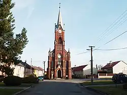 Church of Saint Bartholomew | |
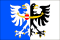 Flag  Coat of arms | |
 Polkovice Location in the Czech Republic | |
| Coordinates: 49°23′30″N 17°15′33″E / 49.39167°N 17.25917°E | |
| Country | |
| Region | Olomouc |
| District | Přerov |
| First mentioned | 1275 |
| Area | |
• Total | 7.06 km2 (2.73 sq mi) |
| Elevation | 199 m (653 ft) |
| Population (2025-01-01)[1] | |
• Total | 503 |
| • Density | 71/km2 (180/sq mi) |
| Time zone | UTC+1 (CET) |
| • Summer (DST) | UTC+2 (CEST) |
| Postal code | 751 44 |
| Website | www |
Polkovice is a municipality and village in Přerov District in the Olomouc Region of the Czech Republic. It has about 500 inhabitants.
Polkovice lies approximately 16 kilometres (10 mi) south-west of Přerov, 23 km (14 mi) south of Olomouc, and 219 km (136 mi) east of Prague.
Demographics
| Year | Pop. | ±% |
|---|---|---|
| 1869 | 662 | — |
| 1880 | 617 | −6.8% |
| 1890 | 638 | +3.4% |
| 1900 | 672 | +5.3% |
| 1910 | 685 | +1.9% |
| 1921 | 716 | +4.5% |
| 1930 | 706 | −1.4% |
| 1950 | 606 | −14.2% |
| 1961 | 623 | +2.8% |
| 1970 | 558 | −10.4% |
| 1980 | 531 | −4.8% |
| 1991 | 483 | −9.0% |
| 2001 | 486 | +0.6% |
| 2011 | 492 | +1.2% |
| 2021 | 485 | −1.4% |
| Source: Censuses[2][3] | ||
References
- ^ "Population of Municipalities – 1 January 2025". Czech Statistical Office. 2025-05-16.
- ^ "Historický lexikon obcí České republiky 1869–2011" (in Czech). Czech Statistical Office. 2015-12-21.
- ^ "Population Census 2021: Population by sex". Public Database. Czech Statistical Office. 2021-03-27.
External links
Wikimedia Commons has media related to Polkovice.