Bratřínov
Bratřínov | |
|---|---|
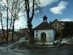 Chapel in Bratřínov | |
 Flag  Coat of arms | |
 Bratřínov Location in the Czech Republic | |
| Coordinates: 49°50′34″N 14°20′25″E / 49.84278°N 14.34028°E | |
| Country | |
| Region | Central Bohemian |
| District | Prague-West |
| First mentioned | 1100 |
| Area | |
• Total | 4.21 km2 (1.63 sq mi) |
| Elevation | 325 m (1,066 ft) |
| Population (2025-01-01)[1] | |
• Total | 206 |
| • Density | 49/km2 (130/sq mi) |
| Time zone | UTC+1 (CET) |
| • Summer (DST) | UTC+2 (CEST) |
| Postal code | 252 05 |
| Website | www |
Bratřínov is a municipality and village in Prague-West District in the Central Bohemian Region of the Czech Republic. It has about 200 inhabitants.
History
The first written mention of Bratřínov is from 1100.[2]
Demographics
| Year | Pop. | ±% |
|---|---|---|
| 1869 | 200 | — |
| 1880 | 197 | −1.5% |
| 1890 | 217 | +10.2% |
| 1900 | 196 | −9.7% |
| 1910 | 196 | +0.0% |
| 1921 | 169 | −13.8% |
| 1930 | 186 | +10.1% |
| 1950 | 132 | −29.0% |
| 1961 | 145 | +9.8% |
| 1970 | 118 | −18.6% |
| 1980 | 100 | −15.3% |
| 1991 | 91 | −9.0% |
| 2001 | 108 | +18.7% |
| 2011 | 189 | +75.0% |
| 2021 | 217 | +14.8% |
| Source: Censuses[3][4] | ||
References
- ^ "Population of Municipalities – 1 January 2025". Czech Statistical Office. 2025-05-16.
- ^ "Historie obce" (in Czech). Obec Bratřínov. Retrieved 2022-03-14.
- ^ "Historický lexikon obcí České republiky 1869–2011" (in Czech). Czech Statistical Office. 2015-12-21.
- ^ "Population Census 2021: Population by sex". Public Database. Czech Statistical Office. 2021-03-27.
External links
Wikimedia Commons has media related to Bratřínov.