Drahelčice
Drahelčice | |
|---|---|
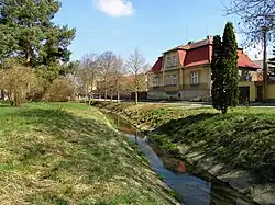 The brook Radotínský potok in Drahelčice | |
 Flag  Coat of arms | |
 Drahelčice Location in the Czech Republic | |
| Coordinates: 50°1′55″N 14°12′11″E / 50.03194°N 14.20306°E | |
| Country | |
| Region | Central Bohemian |
| District | Prague-West |
| First mentioned | 1115 |
| Area | |
• Total | 4.77 km2 (1.84 sq mi) |
| Elevation | 367 m (1,204 ft) |
| Population (2025-01-01)[1] | |
• Total | 1,626 |
| • Density | 340/km2 (880/sq mi) |
| Time zone | UTC+1 (CET) |
| • Summer (DST) | UTC+2 (CEST) |
| Postal code | 252 45 |
| Website | www |
Drahelčice is a municipality and village in Prague-West District in the Central Bohemian Region of the Czech Republic. It has about 1,600 inhabitants.
History
The first written mention is from 1115.[2]
Demographics
| Year | Pop. | ±% |
|---|---|---|
| 1869 | 339 | — |
| 1880 | 330 | −2.7% |
| 1890 | 403 | +22.1% |
| 1900 | 495 | +22.8% |
| 1910 | 548 | +10.7% |
| 1921 | 492 | −10.2% |
| 1930 | 496 | +0.8% |
| 1950 | 492 | −0.8% |
| 1961 | 457 | −7.1% |
| 1970 | 449 | −1.8% |
| 1980 | 414 | −7.8% |
| 1991 | 370 | −10.6% |
| 2001 | 402 | +8.6% |
| 2011 | 559 | +39.1% |
| 2021 | 1,454 | +160.1% |
| Source: Censuses[3][4] | ||
References
- ^ "Population of Municipalities – 1 January 2025". Czech Statistical Office. 2025-05-16.
- ^ "Historie obce" (in Czech). Obec Drahelčice. Retrieved 2021-06-22.
- ^ "Historický lexikon obcí České republiky 1869–2011" (in Czech). Czech Statistical Office. 2015-12-21.
- ^ "Population Census 2021: Population by sex". Public Database. Czech Statistical Office. 2021-03-27.
External links
Wikimedia Commons has media related to Drahelčice.