Casteil
Casteil
Castell de Vernet | |
|---|---|
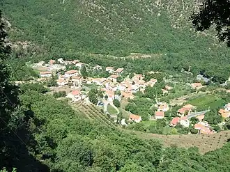 Casteil seen from the access road to the Abbey of Saint-Martin du Canigou | |
 Coat of arms | |
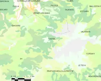
Location of Casteil | |
 Casteil  Casteil | |
| Coordinates: 42°31′55″N 2°23′39″E / 42.5319°N 2.3942°E | |
| Country | France |
| Region | Occitania |
| Department | Pyrénées-Orientales |
| Arrondissement | Prades |
| Canton | Le Canigou |
| Intercommunality | Conflent-Canigó |
| Government | |
| • Mayor (2020–2026) | Olivier Chauveau[1] |
Area 1 | 29.83 km2 (11.52 sq mi) |
| Population (2022)[2] | 140 |
| • Density | 4.7/km2 (12/sq mi) |
| Time zone | UTC+01:00 (CET) |
| • Summer (DST) | UTC+02:00 (CEST) |
| INSEE/Postal code | 66043 /66820 |
| Elevation | 697–2,721 m (2,287–8,927 ft) (avg. 750 m or 2,460 ft) |
| 1 French Land Register data, which excludes lakes, ponds, glaciers > 1 km2 (0.386 sq mi or 247 acres) and river estuaries. | |
Casteil (French pronunciation: [kastɛj] ⓘ; Catalan: Castell de Vernet) is a commune in the Pyrénées-Orientales department in southern France, part of the historical Conflent comarca. The abbey Martin-du-Canigou is located above Casteil.
Geography
Localisation
Casteil is located in the canton of Le Canigou and in the arrondissement of Prades.
Places adjacent to Casteil | |
|---|---|
Population
| Year | Pop. | ±% p.a. |
|---|---|---|
| 1968 | 59 | — |
| 1975 | 50 | −2.34% |
| 1982 | 52 | +0.56% |
| 1990 | 102 | +8.79% |
| 1999 | 130 | +2.73% |
| 2007 | 125 | −0.49% |
| 2012 | 129 | +0.63% |
| 2017 | 136 | +1.06% |
| Source: INSEE[3] | ||
See also
References
- ^ "Répertoire national des élus: les maires" (in French). data.gouv.fr, Plateforme ouverte des données publiques françaises. 13 September 2022.
- ^ "Populations de référence 2022" (in French). The National Institute of Statistics and Economic Studies. 19 December 2024.
- ^ Population en historique depuis 1968, INSEE
Wikimedia Commons has media related to Casteil.