Cropp River
| Cropp River | |
|---|---|
 Cropp River meets the Whitcombe River in the Foreground | |
Route of the Cropp River | |
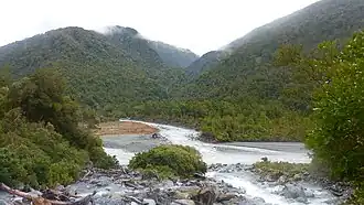
.png) Mouth of the Cropp River  Cropp River (South Island) | |
| Location | |
| Country | New Zealand |
| region | West Coast Region |
| District | Westland District |
| Physical characteristics | |
| Source | Galena Ridge |
| • coordinates | 43°3′50″S 170°55′31″E / 43.06389°S 170.92528°E |
| • elevation | 1,640 m (5,380 ft) |
| Mouth | Whitcombe River |
• coordinates | 43°4′0″S 171°1′36″E / 43.06667°S 171.02667°E |
• elevation | 235 m (771 ft) |
| Length | 10 kilometres (6.2 mi) |
| Basin features | |
| Progression | Cropp River → Whitcombe River → Hokitika River → Tasman Sea |
| River system | Hokitika River |
The Cropp River is a river of New Zealand. It flows east for 10 kilometres (6 mi) before joining the Whitcombe River, a tributary of the Hokitika River.[1][2]
Climate
On 25–26 March 2019, 1,086 millimetres (42.8 in) of rain fell over the Cropp River, a new record rainfall for a 48-hour period for New Zealand.[3]
| Climate data for Cropp River (1981–2010) | |||||||||||||
|---|---|---|---|---|---|---|---|---|---|---|---|---|---|
| Month | Jan | Feb | Mar | Apr | May | Jun | Jul | Aug | Sep | Oct | Nov | Dec | Year |
| Average rainfall mm (inches) | 1,117 (44.0) |
696 (27.4) |
872 (34.3) |
866 (34.1) |
917 (36.1) |
897 (35.3) |
680 (26.8) |
846 (33.3) |
967 (38.1) |
1,240 (48.8) |
1,007 (39.6) |
1,288 (50.7) |
11,393 (448.5) |
| Source: NIWA[4] | |||||||||||||
See also
References
- ^ Peter Dowling, ed. (2004). Reed New Zealand Atlas. Reed Books. Map 75. ISBN 0-7900-0952-8.
- ^ "Place name detail: Cropp River". New Zealand Gazetteer. Land Information New Zealand. Retrieved 29 September 2023.
- ^ "Weather & climate updates for #NewZealand and worldwide". NIWA. 27 March 2019. Retrieved 27 March 2019.
- ^ "THE CLIMATE AND WEATHER OF WEST COAST" (PDF). NIWA. Retrieved 19 February 2025.