Danville, Allegany County, Maryland
Danville, Maryland | |
|---|---|
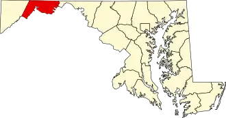
 Danville Location within the State of Maryland  Danville Danville (the United States) | |
| Coordinates: 39°30′45″N 78°55′06″W / 39.51250°N 78.91833°W | |
| Country | |
| State | |
| County | |
| Area | |
• Total | 1.14 sq mi (2.96 km2) |
| • Land | 1.14 sq mi (2.96 km2) |
| • Water | 0.00 sq mi (0.00 km2) |
| Elevation | 1,024 ft (312 m) |
| Population (2020) | |
• Total | 224 |
| • Density | 196.15/sq mi (75.72/km2) |
| Time zone | UTC−5 (Eastern (EST)) |
| • Summer (DST) | UTC−4 (EDT) |
| FIPS code | 24-21675 |
| GNIS feature ID | 2583604[2] |
Danville is an unincorporated community and census-designated place (CDP) in Allegany County, Maryland, United States.[2] As of the 2010 census it had a population of 271.[3]
Danville is located along U.S. Route 220, 14 miles (23 km) southwest of Cumberland, and 6 miles (10 km) northeast of Keyser, West Virginia. The community lies in a valley bounded by 2,800-foot (850 m) Dans Mountain to the northwest and 1,500-foot (460 m) Fort Hill to the southeast.
Demographics
| Census | Pop. | Note | %± |
|---|---|---|---|
| 2020 | 224 | — | |
| U.S. Decennial Census[4] | |||
References
- ^ "2020 U.S. Gazetteer Files". United States Census Bureau. Retrieved April 26, 2022.
- ^ a b c U.S. Geological Survey Geographic Names Information System: Danville, Allegany County, Maryland
- ^ "Geographic Identifiers: 2010 Demographic Profile Data (G001): Danville CDP, Maryland". U.S. Census Bureau, American Factfinder. Archived from the original on February 12, 2020. Retrieved May 24, 2013.
- ^ "Census of Population and Housing". Census.gov. Retrieved June 4, 2016.