Puttelange-aux-Lacs
Puttelange-aux-Lacs | |
|---|---|
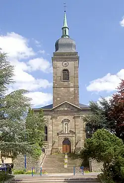 The church in Puttelange-aux-Lacs | |
 Coat of arms | |
Location of Puttelange-aux-Lacs | |
 Puttelange-aux-Lacs  Puttelange-aux-Lacs | |
| Coordinates: 49°03′11″N 6°55′54″E / 49.0531°N 6.9317°E | |
| Country | France |
| Region | Grand Est |
| Department | Moselle |
| Arrondissement | Sarreguemines |
| Canton | Sarralbe |
| Intercommunality | CA Sarreguemines Confluences |
| Government | |
| • Mayor (2020–2026) | Claude Decker[1] |
Area 1 | 16.66 km2 (6.43 sq mi) |
| Population (2022)[2] | 3,058 |
| • Density | 180/km2 (480/sq mi) |
| Time zone | UTC+01:00 (CET) |
| • Summer (DST) | UTC+02:00 (CEST) |
| INSEE/Postal code | 57556 /57510 |
| Elevation | 220–277 m (722–909 ft) (avg. 240 m or 790 ft) |
| 1 French Land Register data, which excludes lakes, ponds, glaciers > 1 km2 (0.386 sq mi or 247 acres) and river estuaries. | |
Puttelange-aux-Lacs (French pronunciation: [pytlɑ̃ʒ o lak]; German: Püttlingen) is a commune in the Moselle department in Grand Est in north-eastern France.
The village is situated on the N56 road.
Population
| Year | Pop. | ±% p.a. |
|---|---|---|
| 1968 | 2,642 | — |
| 1975 | 2,802 | +0.84% |
| 1982 | 3,016 | +1.06% |
| 1990 | 2,979 | −0.15% |
| 1999 | 3,101 | +0.45% |
| 2007 | 3,185 | +0.33% |
| 2012 | 3,113 | −0.46% |
| 2017 | 3,025 | −0.57% |
| Source: INSEE[3] | ||
See also
References
- ^ "Répertoire national des élus: les maires". data.gouv.fr, Plateforme ouverte des données publiques françaises (in French). 2 December 2020.
- ^ "Populations de référence 2022" (in French). The National Institute of Statistics and Economic Studies. 19 December 2024.
- ^ Population en historique depuis 1968, INSEE
External links
 Media related to Puttelange-aux-Lacs at Wikimedia Commons