Dongola Airport
Dongola Airport | |||||||||||
|---|---|---|---|---|---|---|---|---|---|---|---|
 | |||||||||||
| Summary | |||||||||||
| Airport type | Public | ||||||||||
| Serves | Dongola, Sudan | ||||||||||
| Elevation AMSL | 773 ft / 236 m | ||||||||||
| Coordinates | 19°09′13″N 030°25′48″E / 19.15361°N 30.43000°E | ||||||||||
| Map | |||||||||||
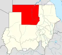 HSDN Location of airport in Sudan (Northern state highlighted) | |||||||||||
| Runways | |||||||||||
| |||||||||||
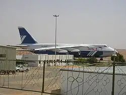
Dongola Airport (IATA: DOG, ICAO: HSDN; Arabic: مطار دنقلا) is an airport serving Dongola,[1] the capital city of the Northern state in Sudan.
History
During the Sudanese civil war (2023–present), the airport was attacked with drones by the Rapid Support Forces on 7 April 2025, destroying a fuel storage facility.[3]
Facilities
The airport resides at an elevation of 773 feet (236 m) above mean sea level. It has one runway designated 17/35 with an asphalt surface measuring 3,000 by 45 metres (9,843 ft × 148 ft).[1]
Airlines and destinations
| Airlines | Destinations |
|---|---|
| Nova Airways | Khartoum (suspended) |
| Tarco Aviation | Port Sudan[4] |
References
- ^ a b c Airport information for HSDN from DAFIF (effective October 2006)
- ^ Airport information for DOG at Great Circle Mapper. Source: DAFIF (effective October 2006).
- ^ "RSF drone attack hits airport fuel depot in Sudan's Northern State". Radio Dabanga. 8 April 2025. Retrieved 8 April 2025.
- ^ "TARCO Aviation Feb 2025 Sudan Domestic Network Additions". Aeroroutes. Retrieved 4 February 2025.