Horní Podluží
Horní Podluží | |
|---|---|
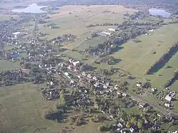 Aerial view | |
 Flag  Coat of arms | |
 Horní Podluží Location in the Czech Republic | |
| Coordinates: 50°52′53″N 14°32′45″E / 50.88139°N 14.54583°E | |
| Country | |
| Region | Ústí nad Labem |
| District | Děčín |
| First mentioned | 1485 |
| Area | |
• Total | 7.44 km2 (2.87 sq mi) |
| Elevation | 436 m (1,430 ft) |
| Population (2025-01-01)[1] | |
• Total | 825 |
| • Density | 110/km2 (290/sq mi) |
| Time zone | UTC+1 (CET) |
| • Summer (DST) | UTC+2 (CEST) |
| Postal code | 407 57 |
| Website | www |
Horní Podluží (until 1947 Horní Grunt; German: Obergrund) is a municipality and village in Děčín District in the Ústí nad Labem Region of the Czech Republic. It has about 800 inhabitants.
Horní Podluží lies approximately 29 kilometres (18 mi) north-east of Děčín, 44 km (27 mi) north-east of Ústí nad Labem, and 89 km (55 mi) north of Prague.
Administrative division
Horní Podluží consists of four municipal parts (in brackets population according to the 2021 census):[2]
- Horní Podluží (694)
- Ladečka (12)
- Světlík (10)
- Žofín (83)
Demographics
| Year | Pop. | ±% |
|---|---|---|
| 1869 | 2,086 | — |
| 1880 | 2,082 | −0.2% |
| 1890 | 2,026 | −2.7% |
| 1900 | 1,946 | −3.9% |
| 1910 | 1,983 | +1.9% |
| 1921 | 1,748 | −11.9% |
| 1930 | 2,088 | +19.5% |
| 1950 | 1,025 | −50.9% |
| 1961 | 813 | −20.7% |
| 1970 | 826 | +1.6% |
| 1980 | 846 | +2.4% |
| 1991 | 687 | −18.8% |
| 2001 | 758 | +10.3% |
| 2011 | 740 | −2.4% |
| 2021 | 799 | +8.0% |
| Source: Censuses[3][4] | ||
References
- ^ "Population of Municipalities – 1 January 2025". Czech Statistical Office. 2025-05-16.
- ^ "Public Census 2021 – basic data". Public Database (in Czech). Czech Statistical Office. 2022.
- ^ "Historický lexikon obcí České republiky 1869–2011" (in Czech). Czech Statistical Office. 2015-12-21.
- ^ "Population Census 2021: Population by sex". Public Database. Czech Statistical Office. 2021-03-27.
External links
Wikimedia Commons has media related to Horní Podluží.