Huntířov
Huntířov | |
|---|---|
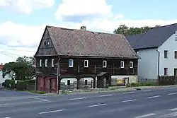 Upper Lusatian house in Huntířov | |
 Coat of arms | |
 Huntířov Location in the Czech Republic | |
| Coordinates: 50°47′22″N 14°18′13″E / 50.78944°N 14.30361°E | |
| Country | |
| Region | Ústí nad Labem |
| District | Děčín |
| First mentioned | 1352 |
| Area | |
• Total | 14.23 km2 (5.49 sq mi) |
| Elevation | 372 m (1,220 ft) |
| Population (2025-01-01)[1] | |
• Total | 815 |
| • Density | 57/km2 (150/sq mi) |
| Time zone | UTC+1 (CET) |
| • Summer (DST) | UTC+2 (CEST) |
| Postal code | 405 02 |
| Website | www |
Huntířov (German: Güntersdorf) is a municipality and village in Děčín District in the Ústí nad Labem Region of the Czech Republic. It has about 800 inhabitants.
Huntířov lies approximately 10 kilometres (6 mi) north-east of Děčín, 25 km (16 mi) north-east of Ústí nad Labem, and 80 km (50 mi) north of Prague.
Administrative division
Huntířov consists of four municipal parts (in brackets population according to the 2021 census):[2]
- Huntířov (366)
- Františkův Vrch (88)
- Nová Oleška (113)
- Stará Oleška (208)
Demographics
| Year | Pop. | ±% |
|---|---|---|
| 1869 | 1,927 | — |
| 1880 | 1,973 | +2.4% |
| 1890 | 1,839 | −6.8% |
| 1900 | 1,733 | −5.8% |
| 1910 | 1,673 | −3.5% |
| 1921 | 1,582 | −5.4% |
| 1930 | 1,663 | +5.1% |
| 1950 | 752 | −54.8% |
| 1961 | 705 | −6.2% |
| 1970 | 631 | −10.5% |
| 1980 | 566 | −10.3% |
| 1991 | 535 | −5.5% |
| 2001 | 697 | +30.3% |
| 2011 | 727 | +4.3% |
| 2021 | 775 | +6.6% |
| Source: Censuses[3][4] | ||
References
- ^ "Population of Municipalities – 1 January 2025". Czech Statistical Office. 2025-05-16.
- ^ "Public Census 2021 – basic data". Public Database (in Czech). Czech Statistical Office. 2022.
- ^ "Historický lexikon obcí České republiky 1869–2011" (in Czech). Czech Statistical Office. 2015-12-21.
- ^ "Population Census 2021: Population by sex". Public Database. Czech Statistical Office. 2021-03-27.
External links
Wikimedia Commons has media related to Huntířov.