Kjósarhreppur
Kjósarhreppur | |
|---|---|
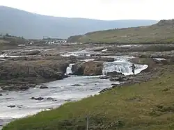 The Laxá river flows through Kjósarhreppur | |
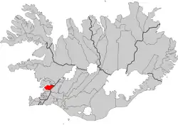 Location of the municipality | |
| Country | Iceland |
| Region | Capital Region |
| Constituency | Southwest Constituency |
| Government | |
| • Manager | Karl Magnús Kristjánsson |
| Area | |
• Total | 284 km2 (110 sq mi) |
| Population (2025)[2] | |
• Total | 301 |
| • Density | 1.1/km2 (2.7/sq mi) |
| Postal code(s) | 276 |
| Municipal number | 1606 |
| Website | kjos |
Kjósarhreppur (Icelandic pronunciation: [ˈcʰouːsar̥ˌr̥ehpʏr̥] ⓘ), colloquially known as Kjós [ˈcʰouːs], is a municipality in Iceland. It is the most northern part of the Capital Region and is adjacent to Reykjavík, Bláskógabyggð, and Hvalfjarðarsveit. Kjós is sometimes referred to as "a countryside in a city" (sveit í borg) due to its proximity to Reykjavík.
The primary industry in Kjós is agriculture.[3] It is home to a number of lakes and rivers, including the Laxá í Kjós, one of the most popular sites for salmon fishing in the country.[4]
References
- ^ "Náttúrufræðistofnun - Sveitarfélagasjá". atlas.lmi.is (in Icelandic). National Land Survey of Iceland. Retrieved 20 March 2025.
- ^ "Population by municipality, age and sex 1998-2025 - Division into municipalites as of 1 January 2025". statice.is. Statistics Iceland. 1 January 2025. Retrieved 20 March 2025.
- ^ Brynja Guðmundsdóttir (2014). Detection of potential arable land with remote sensing and GIS: A Case Study for Kjósarhreppur (PDF) (MS). Lund, Sweden: Lund University. Archived from the original (PDF) on 8 February 2022. Retrieved 26 February 2021.
- ^ Eggert Skúlason (10 May 2020). "Nýr leigutaki með Laxá í Kjós" [New tenant with Laxá í Kjós]. Morgunblaðið (in Icelandic). Reykjavík, Iceland. Retrieved 26 February 2021.
External links
Wikimedia Commons has media related to Kjósarhreppur.
64°20′29.8″N 21°35′33.4″W / 64.341611°N 21.592611°W