Lentvora
Lentvora
Lentő | |
|---|---|
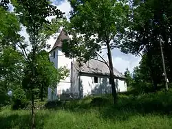 Lutheran Church in Lentvora | |
 Flag | |
 Lentvora Location of Lentvora in the Banská Bystrica Region  Lentvora Location of Lentvora in Slovakia | |
| Coordinates: 48°23′N 19°27′E / 48.38°N 19.45°E | |
| Country | |
| Region | |
| District | Lučenec District |
| First mentioned | 1446 |
| Government | |
| • Mayor | Anna Kropáčová (SMER–SD, HLAS–SD) |
| Area | |
• Total | 13.83 km2 (5.34 sq mi) |
| Elevation | 548 m (1,798 ft) |
| Population (2021)[3] | |
• Total | 77 |
| Time zone | UTC+1 (CET) |
| • Summer (DST) | UTC+2 (CEST) |
| Postal code | 985 13[2] |
| Area code | +421 47[2] |
| Car plate | LC |
| Website | lentvora |
Lentvora (Hungarian: Lentő) is a village and municipality in the Lučenec District in the Banská Bystrica Region of Slovakia.
References
- ^ "Hustota obyvateľstva - obce [om7014rr_ukaz: Rozloha (Štvorcový meter)]". www.statistics.sk (in Slovak). Statistical Office of the Slovak Republic. 2022-03-31. Retrieved 2022-03-31.
- ^ a b c "Základná charakteristika". www.statistics.sk (in Slovak). Statistical Office of the Slovak Republic. 2015-04-17. Retrieved 2022-03-31.
- ^ "Počet obyvateľov podľa pohlavia - obce (ročne)". www.statistics.sk (in Slovak). Statistical Office of the Slovak Republic. 2022-03-31. Retrieved 2022-03-31.
External links
 Media related to Lentvora at Wikimedia Commons
- https://web.archive.org/web/20080111223415/http://www.statistics.sk/mosmis/eng/run.html