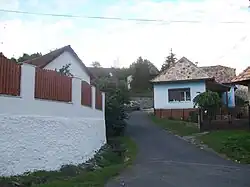
Píla, Lučenec District
Píla
Fűrész | |
|---|---|
 | |
 Flag | |
 Píla Location of Píla in the Banská Bystrica Region  Píla Location of Píla in Slovakia | |
| Coordinates: 48°29′00″N 19°30′26″E / 48.48333°N 19.50722°E | |
| Country | |
| Region | |
| District | Lučenec District |
| First mentioned | 1456 |
| Area | |
• Total | 7.55 km2 (2.92 sq mi) |
| Elevation | 330 m (1,080 ft) |
| Population (2021)[3] | |
• Total | 250 |
| Time zone | UTC+1 (CET) |
| • Summer (DST) | UTC+2 (CEST) |
| Postal code | 985 53[2] |
| Area code | +421 47[2] |
| Car plate | LC |
| Website | www |
Píla (Hungarian: Fűrész) is a village and municipality in the Lučenec District in the Banská Bystrica Region of Slovakia.
References
- ^ "Hustota obyvateľstva - obce [om7014rr_ukaz: Rozloha (Štvorcový meter)]". www.statistics.sk (in Slovak). Statistical Office of the Slovak Republic. 2022-03-31. Retrieved 2022-03-31.
- ^ a b c "Základná charakteristika". www.statistics.sk (in Slovak). Statistical Office of the Slovak Republic. 2015-04-17. Retrieved 2022-03-31.
- ^ "Počet obyvateľov podľa pohlavia - obce (ročne)". www.statistics.sk (in Slovak). Statistical Office of the Slovak Republic. 2022-03-31. Retrieved 2022-03-31.
External links
 Media related to Píla, Lučenec District at Wikimedia Commons
- Official website

- http://www.statistics.sk/mosmis/eng/run.html