Mikolajice
Mikolajice | |
|---|---|
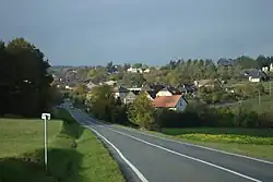 General view | |
 Flag 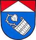 Coat of arms | |
 Mikolajice Location in the Czech Republic | |
| Coordinates: 49°52′38″N 17°47′36″E / 49.87722°N 17.79333°E | |
| Country | |
| Region | Moravian-Silesian |
| District | Opava |
| First mentioned | 1389 |
| Area | |
• Total | 7.40 km2 (2.86 sq mi) |
| Elevation | 354 m (1,161 ft) |
| Population (2025-01-01)[1] | |
• Total | 299 |
| • Density | 40/km2 (100/sq mi) |
| Time zone | UTC+1 (CET) |
| • Summer (DST) | UTC+2 (CEST) |
| Postal code | 747 84 |
| Website | www |
Mikolajice is a municipality and village in Opava District in the Moravian-Silesian Region of the Czech Republic. It has about 300 inhabitants.
History
The first written mention of Mikolajice is from 1389.[2]
Demographics
| Year | Pop. | ±% |
|---|---|---|
| 1869 | 399 | — |
| 1880 | 426 | +6.8% |
| 1890 | 446 | +4.7% |
| 1900 | 403 | −9.6% |
| 1910 | 381 | −5.5% |
| 1921 | 366 | −3.9% |
| 1930 | 363 | −0.8% |
| 1950 | 278 | −23.4% |
| 1961 | 265 | −4.7% |
| 1970 | 236 | −10.9% |
| 1980 | 246 | +4.2% |
| 1991 | 234 | −4.9% |
| 2001 | 251 | +7.3% |
| 2011 | 257 | +2.4% |
| 2021 | 265 | +3.1% |
| Source: Censuses[3][4] | ||
References
- ^ "Population of Municipalities – 1 January 2025". Czech Statistical Office. 2025-05-16.
- ^ "Historie" (in Czech). Obec Mikolajice. Retrieved 2022-03-28.
- ^ "Historický lexikon obcí České republiky 1869–2011" (in Czech). Czech Statistical Office. 2015-12-21.
- ^ "Population Census 2021: Population by sex". Public Database. Czech Statistical Office. 2021-03-27.
External links
Wikimedia Commons has media related to Mikolajice.