Montarcher
Montarcher | |
|---|---|
Commune | |
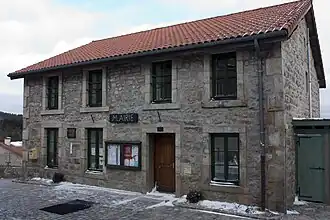 Town hall | |
.svg.png) Coat of arms | |
Location of Montarcher | |
 Montarcher  Montarcher | |
| Coordinates: 45°27′35″N 3°59′48″E / 45.4597°N 3.9967°E | |
| Country | France |
| Region | Auvergne-Rhône-Alpes |
| Department | Loire |
| Arrondissement | Montbrison |
| Canton | Montbrison |
| Intercommunality | CA Loire Forez |
| Government | |
| • Mayor (2020–2026) | Bernard Coutanson[1] |
Area 1 | 5.99 km2 (2.31 sq mi) |
| Population (2022)[2] | 64 |
| • Density | 11/km2 (28/sq mi) |
| Time zone | UTC+01:00 (CET) |
| • Summer (DST) | UTC+02:00 (CEST) |
| INSEE/Postal code | 42146 /42380 |
| Elevation | 938–1,194 m (3,077–3,917 ft) (avg. 1,150 m or 3,770 ft) |
| 1 French Land Register data, which excludes lakes, ponds, glaciers > 1 km2 (0.386 sq mi or 247 acres) and river estuaries. | |
Montarcher is a commune in the Loire department in central France.
Population
| Year | Pop. | ±% p.a. |
|---|---|---|
| 1968 | 87 | — |
| 1975 | 77 | −1.73% |
| 1982 | 54 | −4.94% |
| 1990 | 55 | +0.23% |
| 1999 | 75 | +3.51% |
| 2009 | 63 | −1.73% |
| 2014 | 67 | +1.24% |
| 2020 | 65 | −0.50% |
| Source: INSEE[3] | ||
Geography
The commune lies in the southwestern part of the Loire department, 17 km southwest of Montbrison, 22 km southeast of Ambert and 30 km west of Saint-Étienne.
See also
References
- ^ "Répertoire national des élus: les maires" (in French). data.gouv.fr, Plateforme ouverte des données publiques françaises. 13 September 2022.
- ^ "Populations de référence 2022" (in French). The National Institute of Statistics and Economic Studies. 19 December 2024.
- ^ Population en historique depuis 1968, INSEE
Wikimedia Commons has media related to Montarcher.