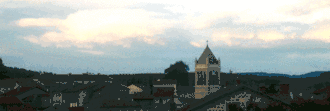
Saint-Genest-Malifaux
Saint-Genest-Malifaux | |
|---|---|
Commune | |
 | |
.svg.png) Coat of arms | |
Location of Saint-Genest-Malifaux | |
 Saint-Genest-Malifaux  Saint-Genest-Malifaux | |
| Coordinates: 45°20′27″N 4°25′14″E / 45.3408°N 4.4206°E | |
| Country | France |
| Region | Auvergne-Rhône-Alpes |
| Department | Loire |
| Arrondissement | Saint-Étienne |
| Canton | Le Pilat |
| Intercommunality | Monts du Pilat |
| Government | |
| • Mayor (2020–2026) | Vincent Ducreux[1] |
Area 1 | 47.08 km2 (18.18 sq mi) |
| Population (2022)[2] | 2,912 |
| • Density | 62/km2 (160/sq mi) |
| Time zone | UTC+01:00 (CET) |
| • Summer (DST) | UTC+02:00 (CEST) |
| INSEE/Postal code | 42224 /42660 |
| Elevation | 680–1,292 m (2,231–4,239 ft) (avg. 960 m or 3,150 ft) |
| 1 French Land Register data, which excludes lakes, ponds, glaciers > 1 km2 (0.386 sq mi or 247 acres) and river estuaries. | |
Saint-Genest-Malifaux (French pronunciation: [sɛ̃ ʒənɛ malifo]) is a small town in the Auvergne-Rhône-Alpes region of central France. Administratively it is designated a commune within the department of Loire.[3]
Population
|
| ||||||||||||||||||||||||||||||||||||||||||||||||||||||
| Source: EHESS[4] and INSEE (1968-2017)[5] | |||||||||||||||||||||||||||||||||||||||||||||||||||||||

See also
References
- ^ "Répertoire national des élus: les maires". data.gouv.fr, Plateforme ouverte des données publiques françaises (in French). 2 December 2020.
- ^ "Populations de référence 2022" (in French). The National Institute of Statistics and Economic Studies. 19 December 2024.
- ^ INSEE commune file
- ^ Des villages de Cassini aux communes d'aujourd'hui: Commune data sheet Saint-Genest-Malifaux, EHESS (in French).
- ^ Population en historique depuis 1968, INSEE
Wikimedia Commons has media related to Saint-Genest-Malifaux.