Pulcifer, Wisconsin
Pulcifer, Wisconsin | |
|---|---|
Census-designated place | |
 | |
 Pulcifer, Wisconsin | |
| Coordinates: 44°50′39″N 88°21′36″W / 44.84417°N 88.36000°W | |
| Country | United States |
| State | Wisconsin |
| County | Shawano |
| Area | |
• Total | 1.038 sq mi (2.69 km2) |
| • Land | 1.033 sq mi (2.68 km2) |
| • Water | 0.005 sq mi (0.01 km2) |
| Elevation | 791 ft (241 m) |
| Population | |
• Total | 131 |
| • Density | 130/sq mi (49/km2) |
| Time zone | UTC-6 (Central (CST)) |
| • Summer (DST) | UTC-5 (CDT) |
| Area codes | 715 & 534 |
| GNIS feature ID | 1571968[2] |
Pulcifer is an unincorporated census-designated place in the town of Green Valley, Shawano County, Wisconsin, United States. Pulcifer is located on the Oconto River and Wisconsin Highway 22 5 miles (8.0 km) northeast of Cecil. As of the 2010 census, its population is 134.[3]
History
The community was named after Daniel H. Pulcifer (1834–1896), who served in the Wisconsin State Assembly and also served as mayor of Shawano, Wisconsin.[4]
Notable people
- Otto A. Risum, Wisconsin State Assemblyman, farmer, and merchant, lived in Pulcifer; Risum served as chairman of the Green Valley Town Board.[5]
References
- ^ "Census Bureau profile: Pulcifer CDP, Wisconsin". United States Census Bureau. May 2023. Retrieved May 10, 2025.
- ^ U.S. Geological Survey Geographic Names Information System: Pulcifer, Wisconsin
- ^ "U.S. Census website". U.S. Census Bureau. Retrieved April 19, 2011.
- ^ "D. H. Pulcifer Dead". The Weekly Wisconsin. Milwaukee, WI. January 25, 1896. p. 1. Retrieved August 4, 2022 – via Newspapers.com.

- ^ 'Wisconsin Blue Book 1897.' Biographical Sketch of Otto A. Risum, pg. 695
External links
 Media related to Pulcifer at Wikimedia Commons
Municipalities and communities of Shawano County, Wisconsin, United States | ||
|---|---|---|
| Cities | 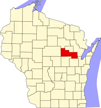 | |
| Villages | ||
| Towns | ||
| CDPs | ||
| Other communities | ||
| Indian reservations | ||
| Footnotes | ‡This populated place also has portions in an adjacent county or counties | |