Račín
Račín | |
|---|---|
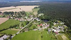 Aerial view from the southwest | |
 Flag  Coat of arms | |
 Račín Location in the Czech Republic | |
| Coordinates: 49°37′3″N 15°52′0″E / 49.61750°N 15.86667°E | |
| Country | |
| Region | Vysočina |
| District | Žďár nad Sázavou |
| First mentioned | 1654 |
| Area | |
• Total | 7.96 km2 (3.07 sq mi) |
| Elevation | 648 m (2,126 ft) |
| Population (2025-01-01)[1] | |
• Total | 144 |
| • Density | 18/km2 (47/sq mi) |
| Time zone | UTC+1 (CET) |
| • Summer (DST) | UTC+2 (CEST) |
| Postal code | 592 11 |
| Website | obecracin |
Račín is a municipality and village in Žďár nad Sázavou District in the Vysočina Region of the Czech Republic. It has about 100 inhabitants.
Račín lies approximately 8 kilometres (5 mi) north-west of Žďár nad Sázavou, 31 km (19 mi) north-east of Jihlava, and 117 km (73 mi) south-east of Prague.
Demographics
| Year | Pop. | ±% |
|---|---|---|
| 1869 | 194 | — |
| 1880 | 166 | −14.4% |
| 1890 | 165 | −0.6% |
| 1900 | 156 | −5.5% |
| 1910 | 175 | +12.2% |
| 1921 | 150 | −14.3% |
| 1930 | 137 | −8.7% |
| 1950 | 116 | −15.3% |
| 1961 | 138 | +19.0% |
| 1970 | 128 | −7.2% |
| 1980 | 114 | −10.9% |
| 1991 | 91 | −20.2% |
| 2001 | 87 | −4.4% |
| 2011 | 118 | +35.6% |
| 2021 | 129 | +9.3% |
| Source: Censuses[2][3] | ||
References
- ^ "Population of Municipalities – 1 January 2025". Czech Statistical Office. 2025-05-16.
- ^ "Historický lexikon obcí České republiky 1869–2011" (in Czech). Czech Statistical Office. 2015-12-21.
- ^ "Population Census 2021: Population by sex". Public Database. Czech Statistical Office. 2021-03-27.
External links
Wikimedia Commons has media related to Račín.