Sairé
Sairé | |
|---|---|
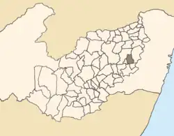 Location of Sairé within Pernambuco. | |
| Country | Brazil |
| State | Pernambuco |
| Region | Agreste Pernambucano |
| Area | |
• Total | 195.46 km2 (75.47 sq mi) |
| Elevation | 663 m (2,175 ft) |
| Population (2020) | |
• Total | 9,764 |
| Time zone | UTC-3 (BRT) |
| • Summer (DST) | UTC-2 (BRST) |

Sairé is a municipality located in the state of Pernambuco, Brazil. Located at 110.7 km away from Recife, capital of the state of Pernambuco. Has an estimated (IBGE 2020) population of 9,764 inhabitants.[1]
Geography
- State - Pernambuco
- Region - Agreste Pernambucano
- Boundaries - Bezerros (N); Bonito and Barra de Guabiraba (S); Gravatá (E); Camocim de São Félix (W).
- Area - 195.46 km2
- Elevation - 663 m
- Hydrography - Ipojuca and Sirinhaém rivers
- Vegetation - Subcaducifólia and hipoxerófila
- Climate - Tropical hot and humid
- Annual average temperature - 24.0 c
- Distance to Recife - 110.7 km
Economy
The main economic activities in Sairé are based in agribusiness, especially tomatoes, tangerines, passion fruits; and livestock such as cattle, sheep and poultry.
Economic indicators
| Population[2] | GDP x(1000 R$).[3] | GDP pc (R$) | PE |
|---|---|---|---|
| 14.194 | 48.553 | 3.542 | 0.08% |
Economy by Sector 2006
| Primary sector | Secondary sector | Service sector |
|---|---|---|
| 21.24% | 9.69% | 69.07% |
Health indicators
| HDI (2000) | Hospitals (2007) | Hospitals beds (2007) | Children's Mortality every 1000 (2005) |
|---|---|---|---|
| 0.598 | 1 | 20 | 27 |
See also
References
- ^ IBGE 2020
- ^ http://www.ibge.gov.br/home/estatistica/populacao/estimativa2009/POP2009_DOU.pdfIBGE Population 2009 Sairé, page 34]
- ^ Sairé 2007 GDP IBGE page 32 Archived 2016-03-04 at the Wayback Machine
- ^ PE State site - City by city profile
Capital: Recife | ||||||||||||||
| Mesoregion Agreste Pernambucano |
|  | ||||||||||||
| Mesoregion Mata Pernambucana |
| |||||||||||||
| Mesoregion Metropolitana de Recife |
| |||||||||||||
| Mesoregion Sao Francisco Pernambucano |
| |||||||||||||
| Mesoregion Sertão Pernambucano |
| |||||||||||||