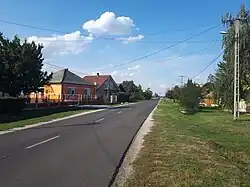
Sajóhídvég
Sajóhídvég | |
|---|---|
Village | |
 | |
 Flag  Coat of arms | |
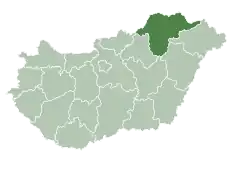
 Sajóhídvég Location of Sajóhídvég | |
| Coordinates: 48°00′15″N 20°57′02″E / 48.0042°N 20.9505°E | |
| Country | Hungary |
| Region | Northern Hungary |
| County | Borsod-Abaúj-Zemplén |
| District | Miskolc |
| Area | |
• Total | 13.45 km2 (5.19 sq mi) |
| Population (1 January 2024)[1] | |
• Total | 1,026 |
| • Density | 76/km2 (200/sq mi) |
| Time zone | UTC+1 (CET) |
| • Summer (DST) | UTC+2 (CEST) |
| Postal code | 3576 |
| Area code | (+36) 49 |
| Website | sajohidveg |
Sajóhídvég is a village in Borsod-Abaúj-Zemplén County in north-eastern Hungary.[2]
References
- ^ Detailed Gazetteer of Hungary. 23 September 2024 https://www.ksh.hu/apps/hntr.telepules?p_lang=EN&p_id=03081. Retrieved 23 September 2024.
{{cite web}}: Missing or empty|title=(help) - ^ Központi Statisztikai Hivatal (KSH) (in Hungarian)