San Jacinto, Indiana
San Jacinto, Indiana | |
|---|---|
 San Jacinto  San Jacinto | |
| Coordinates: 38°57′23″N 85°29′50″W / 38.95639°N 85.49722°W | |
| Country | United States |
| State | Indiana |
| County | Jennings |
| Township | Bigger |
| Elevation | 751 ft (229 m) |
| ZIP code | 47223 |
| FIPS code | 18-67986[2] |
| GNIS feature ID | 442956[1] |
San Jacinto is an unincorporated community in Bigger Township, Jennings County, Indiana.
History
A post office was established at San Jacinto in 1852, and remained in operation until it was discontinued in 1906.[3] The name of the community commemorates the Battle of San Jacinto.[4]
References
- ^ a b U.S. Geological Survey Geographic Names Information System: San Jacinto, Indiana
- ^ "U.S. Census website". United States Census Bureau. Retrieved January 31, 2008.
- ^ "Jennings County". Jim Forte Postal History. Retrieved November 9, 2014.
- ^ Jennings Co. Historical Society (1999). Jennings Co, Indiana - Pictorial. Turner Publishing Company. p. 30. ISBN 9781563115219.
Municipalities and communities of Jennings County, Indiana, United States | ||
|---|---|---|
| City | 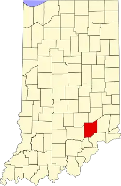 | |
| Town | ||
| Townships | ||
| CDPs | ||
| Other communities | ||
| Footnotes | ‡This populated place also has portions in an adjacent county or counties | |