Springdale, New South Wales
| Springdale New South Wales | |
|---|---|
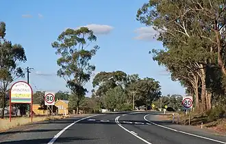 Entering Springdale | |
 Springdale | |
| Coordinates | 34°27′S 147°43′E / 34.450°S 147.717°E |
| Population | 126 (SAL 2021)[1] |
| Postcode(s) | 2666 |
| Location |
|
| LGA(s) | Temora Shire |
| County | Bland |
| State electorate(s) | Cootamundra |
| Federal division(s) | Riverina |
Springdale is a village community in the central north part of the Riverina region of the Australian state of New South Wales.[2] It is situated by road, about 3 kilometres east of Combaning and 23 kilometres north west of Stockinbingal. At the 2016 census, it had a population of 150.[3]
Springdale Post Office opened on 1 November 1897 and closed in 1977.[4] A railway station on the branch line to Lake Cargelligo served the community between 1893 and 1975.[5]
Gallery
-
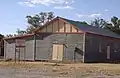 Springdale Functions Hall
 -
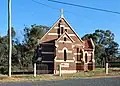 All Saints Anglican church
 -
 War memorial
Springdale railway station
| Preceding station | Former services | Following station | ||
|---|---|---|---|---|
| Combaning towards Lake Cargelligo
|
Lake Cargelligo Line | Gundibindyal towards Cootamundra
| ||
References
- ^ Australian Bureau of Statistics (28 June 2022). "Springdale (NSW) (suburb and locality)". Australian Census 2021 QuickStats. Retrieved 28 June 2022.
- ^ "Springdale". Geographical Names Register (GNR) of NSW. Geographical Names Board of New South Wales.
- ^ Australian Bureau of Statistics (27 June 2017). "Springdale". 2016 Census QuickStats. Retrieved 3 August 2020.
- ^ Phoenix Auctions, Post Office List, retrieved 24 January 2021
- ^ Combaning station. NSWrail.net, accessed 6 September 2009.