Straß im Straßertale
Straß im Straßertale | |
|---|---|
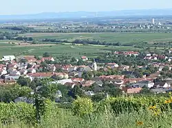 Remote view | |
 Coat of arms | |
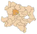
 Straß im Straßertale Location within Austria | |
| Coordinates: 48°28′N 15°44′E / 48.467°N 15.733°E | |
| Country | Austria |
| State | Lower Austria |
| District | Krems-Land |
| Government | |
| • Mayor | Martin Leuthner (ÖVP) |
| Area | |
• Total | 22.49 km2 (8.68 sq mi) |
| Elevation | 217 m (712 ft) |
| Population (2018-01-01)[2] | |
• Total | 1,678 |
| • Density | 75/km2 (190/sq mi) |
| Time zone | UTC+1 (CET) |
| • Summer (DST) | UTC+2 (CEST) |
| Postal code | 3491 |
| Area code | 02735 |
| Website | www.members.aon.at/strassertal |
Straß im Straßertale is a town in the district of Krems-Land in Lower Austria in Austria.
Population
| Year | Pop. | ±% |
|---|---|---|
| 1971 | 1,497 | — |
| 1981 | 1,420 | −5.1% |
| 1991 | 1,402 | −1.3% |
| 2001 | 1,465 | +4.5% |
| 2011 | 1,565 | +6.8% |
| 2021 | 1,750 | +11.8% |
References
- ^ "Dauersiedlungsraum der Gemeinden Politischen Bezirke und Bundesländer - Gebietsstand 1.1.2018". Statistics Austria. Retrieved 10 March 2019.
- ^ "Einwohnerzahl 1.1.2018 nach Gemeinden mit Status, Gebietsstand 1.1.2018". Statistics Austria. Retrieved 9 March 2019.