Syrovátka
Syrovátka | |
|---|---|
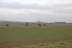 View from the west | |
 Flag  Coat of arms | |
 Syrovátka Location in the Czech Republic | |
| Coordinates: 50°9′17″N 15°39′46″E / 50.15472°N 15.66278°E | |
| Country | |
| Region | Hradec Králové |
| District | Hradec Králové |
| First mentioned | 1339 |
| Area | |
• Total | 1.83 km2 (0.71 sq mi) |
| Elevation | 257 m (843 ft) |
| Population (2025-01-01)[1] | |
• Total | 463 |
| • Density | 250/km2 (660/sq mi) |
| Time zone | UTC+1 (CET) |
| • Summer (DST) | UTC+2 (CEST) |
| Postal code | 503 27 |
| Website | www |
Syrovátka is a municipality and village in Hradec Králové District in the Hradec Králové Region of the Czech Republic. It has about 500 inhabitants.
Demographics
| Year | Pop. | ±% |
|---|---|---|
| 1869 | 354 | — |
| 1880 | 385 | +8.8% |
| 1890 | 384 | −0.3% |
| 1900 | 366 | −4.7% |
| 1910 | 364 | −0.5% |
| 1921 | 346 | −4.9% |
| 1930 | 434 | +25.4% |
| 1950 | 372 | −14.3% |
| 1961 | 429 | +15.3% |
| 1970 | 432 | +0.7% |
| 1980 | 387 | −10.4% |
| 1991 | 339 | −12.4% |
| 2001 | 383 | +13.0% |
| 2011 | 398 | +3.9% |
| 2021 | 424 | +6.5% |
| Source: Censuses[2][3] | ||
References
- ^ "Population of Municipalities – 1 January 2025". Czech Statistical Office. 2025-05-16.
- ^ "Historický lexikon obcí České republiky 1869–2011" (in Czech). Czech Statistical Office. 2015-12-21.
- ^ "Population Census 2021: Population by sex". Public Database. Czech Statistical Office. 2021-03-27.
External links
Wikimedia Commons has media related to Syrovátka.