Tatenice
Tatenice | |
|---|---|
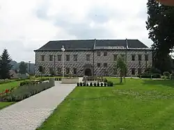 Tatenice Castle | |
 Flag  Coat of arms | |
 Tatenice Location in the Czech Republic | |
| Coordinates: 49°52′16″N 16°41′50″E / 49.87111°N 16.69722°E | |
| Country | |
| Region | Pardubice |
| District | Ústí nad Orlicí |
| First mentioned | 1267 |
| Area | |
• Total | 26.82 km2 (10.36 sq mi) |
| Elevation | 344 m (1,129 ft) |
| Population (2025-01-01)[1] | |
• Total | 903 |
| • Density | 34/km2 (87/sq mi) |
| Time zone | UTC+1 (CET) |
| • Summer (DST) | UTC+2 (CEST) |
| Postal code | 561 31 |
| Website | www |
Tatenice (German: Tattenitz) is a municipality and village in Ústí nad Orlicí District in the Pardubice Region of the Czech Republic. It has about 900 inhabitants.
Tatenice lies approximately 25 kilometres (16 mi) south-east of Ústí nad Orlicí, 69 km (43 mi) east of Pardubice, and 165 km (103 mi) east of Prague.
Demographics
| Year | Pop. | ±% |
|---|---|---|
| 1869 | 1,651 | — |
| 1880 | 1,610 | −2.5% |
| 1890 | 1,639 | +1.8% |
| 1900 | 1,582 | −3.5% |
| 1910 | 1,448 | −8.5% |
| 1921 | 1,400 | −3.3% |
| 1930 | 1,364 | −2.6% |
| 1950 | 806 | −40.9% |
| 1961 | 908 | +12.7% |
| 1970 | 875 | −3.6% |
| 1980 | 868 | −0.8% |
| 1991 | 819 | −5.6% |
| 2001 | 841 | +2.7% |
| 2011 | 839 | −0.2% |
| 2021 | 831 | −1.0% |
| Source: Censuses[2][3] | ||
References
- ^ "Population of Municipalities – 1 January 2025". Czech Statistical Office. 2025-05-16.
- ^ "Historický lexikon obcí České republiky 1869–2011" (in Czech). Czech Statistical Office. 2015-12-21.
- ^ "Population Census 2021: Population by sex". Public Database. Czech Statistical Office. 2021-03-27.
External links
Wikimedia Commons has media related to Tatenice.