Tram, Kentucky
Tram, Kentucky | |
|---|---|
 Tram Location in Kentucky | |
| Coordinates: 37°34′10″N 82°38′51″W / 37.56944°N 82.64750°W | |
| Country | |
| State | |
| County | Floyd |
| Elevation | 250 m (820 ft) |
| Time zone | UTC-5 (Eastern (EST)) |
| • Summer (DST) | UTC-4 (EDT) |
| ZIP code | 41663[1] |
| Area code | 606 |
| GNIS feature ID | 2629696 |
| U.S. Geological Survey Geographic Names Information System: Tram, Kentucky | |
Tram is an unincorporated community in Floyd County, Kentucky, United States.[2]
References
- ^ "Tram ZIP Code". zipdatamaps.com. 2022. Retrieved November 30, 2022.
- ^ "Feature Detail Report for: Tram, Kentucky." USGS. U.S. Geological Survey Geographic Names Information System: Tram, Kentucky Retrieved May 12, 2011.
Municipalities and communities of Floyd County, Kentucky, United States | ||
|---|---|---|
| Cities | 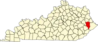 | |
| CDPs | ||
| Other unincorporated communities |
| |
| Footnotes | ‡This populated place also has portions in an adjacent county or counties. | |