Všestudy (Chomutov District)
Všestudy | |
|---|---|
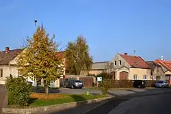 Centre of Všestudy | |
%252C_vlajka.svg.png) Flag %252C_znak.jpg) Coat of arms | |
 Všestudy Location in the Czech Republic | |
| Coordinates: 50°27′27″N 13°30′28″E / 50.45750°N 13.50778°E | |
| Country | |
| Region | Ústí nad Labem |
| District | Chomutov |
| First mentioned | 1325 |
| Area | |
• Total | 5.11 km2 (1.97 sq mi) |
| Elevation | 317 m (1,040 ft) |
| Population (2025-01-01)[1] | |
• Total | 176 |
| • Density | 34/km2 (89/sq mi) |
| Time zone | UTC+1 (CET) |
| • Summer (DST) | UTC+2 (CEST) |
| Postal code | 431 11 |
| Website | www |
Všestudy (German: Schößl) is a municipality and village in Chomutov District in the Ústí nad Labem Region of the Czech Republic. It has about 200 inhabitants.
Všestudy lies approximately 8 kilometres (5 mi) east of Chomutov, 44 km (27 mi) south-west of Ústí nad Labem, and 77 km (48 mi) north-west of Prague.
Demographics
| Year | Pop. | ±% |
|---|---|---|
| 1869 | 255 | — |
| 1880 | 281 | +10.2% |
| 1890 | 275 | −2.1% |
| 1900 | 291 | +5.8% |
| 1910 | 280 | −3.8% |
| 1921 | 299 | +6.8% |
| 1930 | 312 | +4.3% |
| 1950 | 171 | −45.2% |
| 1961 | 177 | +3.5% |
| 1970 | 138 | −22.0% |
| 1980 | 101 | −26.8% |
| 1991 | 155 | +53.5% |
| 2001 | 178 | +14.8% |
| 2011 | 172 | −3.4% |
| 2021 | 176 | +2.3% |
| Source: Censuses[2][3] | ||
References
- ^ "Population of Municipalities – 1 January 2025". Czech Statistical Office. 2025-05-16.
- ^ "Historický lexikon obcí České republiky 1869–2011" (in Czech). Czech Statistical Office. 2015-12-21.
- ^ "Population Census 2021: Population by sex". Public Database. Czech Statistical Office. 2021-03-27.
External links
Wikimedia Commons has media related to Všestudy (Chomutov District).