Vernířovice
Vernířovice | |
|---|---|
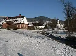 View towards the Church of Saint Matthew | |
 Flag 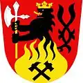 Coat of arms | |
 Vernířovice Location in the Czech Republic | |
| Coordinates: 50°1′54″N 17°7′49″E / 50.03167°N 17.13028°E | |
| Country | Czech Republic |
| Region | Olomouc |
| District | Šumperk |
| First mentioned | 1558 |
| Area | |
• Total | 33.30 km2 (12.86 sq mi) |
| Elevation | 524 m (1,719 ft) |
| Population (2025-01-01)[1] | |
• Total | 199 |
| • Density | 6.0/km2 (15/sq mi) |
| Time zone | UTC+1 (CET) |
| • Summer (DST) | UTC+2 (CEST) |
| Postal codes | 788 15 |
| Website | www |
Vernířovice (German: Wermsdorf) is a municipality and village in Šumperk District in the Olomouc Region of the Czech Republic. It has about 200 inhabitants.
Vernířovice lies approximately 14 kilometres (9 mi) north-east of Šumperk, 50 km (31 mi) north of Olomouc, and 194 km (121 mi) east of Prague.
Demographics
| Year | Pop. | ±% |
|---|---|---|
| 1869 | 1,381 | — |
| 1880 | 1,389 | +0.6% |
| 1890 | 1,324 | −4.7% |
| 1900 | 1,206 | −8.9% |
| 1910 | 1,141 | −5.4% |
| 1921 | 975 | −14.5% |
| 1930 | 964 | −1.1% |
| 1950 | 314 | −67.4% |
| 1961 | 424 | +35.0% |
| 1970 | 370 | −12.7% |
| 1980 | 249 | −32.7% |
| 1991 | 182 | −26.9% |
| 2001 | 179 | −1.6% |
| 2011 | 193 | +7.8% |
| 2021 | 200 | +3.6% |
| Source: Censuses[2][3] | ||
References
- ^ "Population of Municipalities – 1 January 2025". Czech Statistical Office. 2025-05-16.
- ^ "Historický lexikon obcí České republiky 1869–2011" (in Czech). Czech Statistical Office. 2015-12-21.
- ^ "Population Census 2021: Population by sex". Public Database. Czech Statistical Office. 2021-03-27.
External links
Wikimedia Commons has media related to Vernířovice.