Aracitaba
Aracitaba | |
|---|---|
 Flag  Coat of arms | |
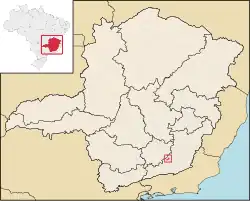 Location in Minas Gerais | |
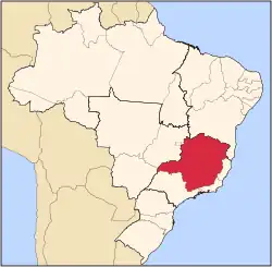
 Location in Brazil | |
| Coordinates: 21°20′34″S 43°22′40″W / 21.34278°S 43.37778°W | |
| Country | Brazil |
| Region | Southeast Region |
| State | Minas Gerais |
| Mesoregion | Zona da Mata |
| Microregion | Juiz de Fora |
| Government | |
| • Major | Fábio Alfeu da Silva (MDB) |
| Area | |
• Total | 105.885 km2 (40.882 sq mi) |
| Population (2020 [1]) | |
• Total | 2,059 |
| • Density | 19/km2 (50/sq mi) |
| Demonym | aracitabense [2] |
| Time zone | UTC−3 (BRT) |
| CEP postal code | 36255-000 |
| Area code | 32 |
| Website | aracitaba |
Aracitaba is a Brazilian municipality located in the state of Minas Gerais. Its population as of 2020 is estimated to be 2,059 people living in a total area of 105,885 km². The city belongs to the mesoregion of Zona da Mata and to the microregion of Juiz de Fora.
See also
References
- ^ IBGE 2020
- ^ "IBGE - Cidades@". O Brasil Município por Município. Brazilian Institute of Geography and Statistics (IBGE). Retrieved 2018-01-17.