Santo Antônio do Jacinto
Santo Antônio do Jacinto | |
|---|---|
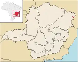 Location in Minas Gerais state | |
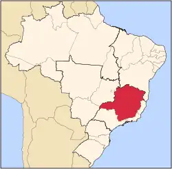
 Santo Antônio do Jacinto Location in Brazil | |
| Coordinates: 16°32′2″S 40°10′33″W / 16.53389°S 40.17583°W | |
| Country | Brazil |
| Region | Southeast |
| State | Minas Gerais |
| Intermediate Geographic Region | Teófilo Otoni |
| Immediate Geographic Region | Almenara |
| Area | |
• Total | 503.38 km2 (194.36 sq mi) |
| Population (2020 [1]) | |
• Total | 11,604 |
| • Density | 23/km2 (60/sq mi) |
| Time zone | UTC−3 (BRT) |
Santo Antônio do Jacinto (first part, Portuguese meaning "Saint Anthony") is a municipality in the northeastern part of the state of Minas Gerais, Brazil. The population is 11,604 (2020 est.) in an area of 503.38 km².[2]
Neighboring municipalities
Population history
| Year | Population |
|---|---|
| 2004 | 12,170 |
| 2006 | 12,182 |
| 2015 | 12,008 |
See also
References
External links
- http://www.citybrazil.com.br/sp/stoantoniojacinto/ (in Portuguese)