Santo Antônio do Itambé
Santo Antônio do Itambé | |
|---|---|
.jpg) Church of Saint Anthony, Santo Antônio do Itambé | |
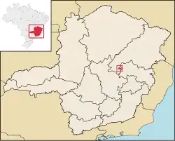 Location in Minas Gerais state | |
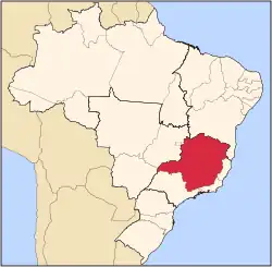
 Santo Antônio do Itambé Location in Brazil | |
| Coordinates: 18°27′57″S 43°18′25″W / 18.46583°S 43.30694°W | |
| Country | Brazil |
| Region | Southeast |
| State | Minas Gerais |
| Mesoregion | Metropolitana de Belo Horizonte |
| Government | |
| • Mayor | Ronam Sales [1] (PDT) |
| Area | |
• Total | 305.74 km2 (118.05 sq mi) |
| Population (2020 [2]) | |
• Total | 3,799 |
| • Density | 12/km2 (32/sq mi) |
| Time zone | UTC−3 (BRT) |
| Postal code | 39160-000 |
| Area code | 33 |
Santo Antônio do Itambé is a municipality in the state of Minas Gerais, Brazil. The population is 3,799 (2020 est.) in an area of 305.74 km².[4]
The municipality contains part of the 4,696 hectares (11,600 acres) Pico do Itambé State Park, created in 1998.[5]
See also
References
- ^ "Resultado das Eleições e Apuração Santo Antônio do Itambé-MG no 1º Turno | G1 Eleições".
- ^ IBGE 2020
- ^ "Santo Antônio do Itambé". Archived from the original on 2020-09-27.
- ^ Instituto Brasileiro de Geografia e Estatística
- ^ Parque Estadual do Pico do Itambé (in Portuguese), IEF: Instituto Estadual de Florestas, archived from the original on 2019-03-27, retrieved 2016-12-19
{{citation}}: CS1 maint: publisher location (link)
External links
- (in Portuguese) http://www.citybrazil.com.br/sp/stoantonioitambe/ (in Portuguese)