Aurec-sur-Loire
Aurec-sur-Loire | |
|---|---|
Commune | |
 | |
 Coat of arms | |
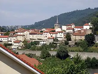
Location of Aurec-sur-Loire | |
 Aurec-sur-Loire  Aurec-sur-Loire | |
| Coordinates: 45°22′12″N 4°12′09″E / 45.37°N 4.2025°E | |
| Country | France |
| Region | Auvergne-Rhône-Alpes |
| Department | Haute-Loire |
| Arrondissement | Yssingeaux |
| Canton | Aurec-sur-Loire |
| Intercommunality | Loire et Semène |
| Government | |
| • Mayor (2020–2026) | Claude Vial[1] |
Area 1 | 22.44 km2 (8.66 sq mi) |
| Population (2022)[2] | 6,133 |
| • Density | 270/km2 (710/sq mi) |
| Time zone | UTC+01:00 (CET) |
| • Summer (DST) | UTC+02:00 (CEST) |
| INSEE/Postal code | 43012 /43110 |
| Elevation | 414–821 m (1,358–2,694 ft) (avg. 432 m or 1,417 ft) |
| 1 French Land Register data, which excludes lakes, ponds, glaciers > 1 km2 (0.386 sq mi or 247 acres) and river estuaries. | |
Aurec-sur-Loire (French pronunciation: [oʁɛk syʁ lwaʁ], literally Aurec on Loire; Occitan: Aurec) is a commune in the Haute-Loire department in south-central France.
Population
|
| ||||||||||||||||||||||||||||||||||||||||||||||||||||||||||||||||||||||||||||||||||||||||||||||||||||||||||||||||||
| Source: EHESS[3] and INSEE (1968-2017)[4] | |||||||||||||||||||||||||||||||||||||||||||||||||||||||||||||||||||||||||||||||||||||||||||||||||||||||||||||||||||
Galleries
-
 Ramparts.
 -
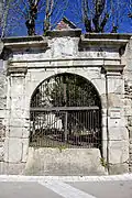 Former doorway to the Castle.
 -
 North face
 -
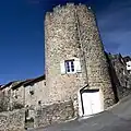 Tower of the Burgundians.
 -
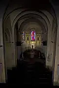 Nave.
Nave. -
 Baptismal Fonts
 -
.jpg) Altar and altarpiece.
Altar and altarpiece. -
 Pieta.
 -
 St. Peter.
 -
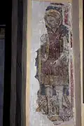 St. Michael.
See also
References
- ^ "Répertoire national des élus: les maires". data.gouv.fr, Plateforme ouverte des données publiques françaises (in French). 2 December 2020.
- ^ "Populations de référence 2022" (in French). The National Institute of Statistics and Economic Studies. 19 December 2024.
- ^ Des villages de Cassini aux communes d'aujourd'hui: Commune data sheet Aurec-sur-Loire, EHESS (in French).
- ^ Population en historique depuis 1968, INSEE
Wikimedia Commons has media related to Aurec-sur-Loire.