Břevnice
Břevnice | |
|---|---|
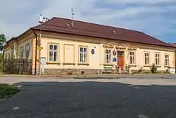 Municipal office | |
 Flag  Coat of arms | |
 Břevnice Location in the Czech Republic | |
| Coordinates: 49°37′53″N 15°36′45″E / 49.63139°N 15.61250°E | |
| Country | |
| Region | Vysočina |
| District | Havlíčkův Brod |
| First mentioned | 1351 |
| Area | |
• Total | 3.37 km2 (1.30 sq mi) |
| Elevation | 435 m (1,427 ft) |
| Population (2025-01-01)[1] | |
• Total | 162 |
| • Density | 48/km2 (120/sq mi) |
| Time zone | UTC+1 (CET) |
| • Summer (DST) | UTC+2 (CEST) |
| Postal code | 580 01 |
| Website | www |
Břevnice (Czech pronunciation: [ˈbr̝ɛvɲɪtsɛ]; German: Hrzebnicz) is a municipality and village in Havlíčkův Brod District in the Vysočina Region of the Czech Republic. It has about 200 inhabitants.
Břevnice lies approximately 5 kilometres (3 mi) north-east of Havlíčkův Brod, 28 km (17 mi) north of Jihlava, and 99 km (62 mi) south-east of Prague.
Demographics
| Year | Pop. | ±% |
|---|---|---|
| 1869 | 294 | — |
| 1880 | 257 | −12.6% |
| 1890 | 208 | −19.1% |
| 1900 | 198 | −4.8% |
| 1910 | 241 | +21.7% |
| 1921 | 241 | +0.0% |
| 1930 | 233 | −3.3% |
| 1950 | 185 | −20.6% |
| 1961 | 205 | +10.8% |
| 1970 | 201 | −2.0% |
| 1980 | 165 | −17.9% |
| 1991 | 164 | −0.6% |
| 2001 | 164 | +0.0% |
| 2011 | 168 | +2.4% |
| 2021 | 168 | +0.0% |
| Source: Censuses[2][3] | ||
References
- ^ "Population of Municipalities – 1 January 2025". Czech Statistical Office. 2025-05-16.
- ^ "Historický lexikon obcí České republiky 1869–2011" (in Czech). Czech Statistical Office. 2015-12-21.
- ^ "Population Census 2021: Population by sex". Public Database. Czech Statistical Office. 2021-03-27.
External links
Wikimedia Commons has media related to Břevnice.