Ceglédbercel
Ceglédbercel | |
|---|---|
 Coat of arms | |
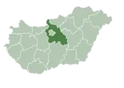
 Ceglédbercel Location of Ceglédbercel in Hungary | |
| Coordinates: 47°13′21″N 19°39′59″E / 47.22248°N 19.66636°E | |
| Country | Hungary |
| Region | Central Hungary |
| County | Pest |
| Area | |
• Total | 2.815 km2 (1.087 sq mi) |
| Population (1 January 2009)[2] | |
• Total | 4,440 |
| • Density | 1,600/km2 (4,100/sq mi) |
| Time zone | UTC+1 (CET) |
| • Summer (DST) | UTC+2 (CEST) |
| Postal code | 2737 |
| Area code | +36 53 |
| KSH code | 20640[1] |
| Website | http://www.cegledbercel.hu |
Ceglédbercel is a village in Pest County, Hungary.
References
- ^ a b Ceglédbercel at the Hungarian Central Statistical Office (Hungarian).
- ^ Ceglédbercel at the Hungarian Central Statistical Office (Hungarian). 1 January 2009