Tápiógyörgye
Tápiógyörgye | |
|---|---|
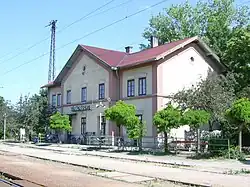 Train station | |
 Flag  Coat of arms | |
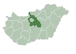
 Tápiógyörgye Location of Tápiógyörgye in Hungary | |
| Coordinates: 47°20′1.68″N 19°57′14.87″E / 47.3338000°N 19.9541306°E | |
| Country | Hungary |
| Region | Central Hungary |
| County | Pest |
| District | Nagykáta |
| Rank | Village |
| Area | |
• Total | 53.31 km2 (20.58 sq mi) |
| Population (1 January 2008)[2] | |
• Total | 3,780 |
| • Density | 71/km2 (180/sq mi) |
| Time zone | UTC+1 (CET) |
| • Summer (DST) | UTC+2 (CEST) |
| Postal code | 2767 |
| Area code | +36 53 |
| KSH code | 17303[1] |
| Website | www.Tapiogyorgye.hu |
Tápiógyörgye is a village in Pest county, Hungary.
References
- ^ a b Tápiógyörgye at the Hungarian Central Statistical Office (Hungarian).
- ^ Tápiógyörgye at the Hungarian Central Statistical Office (Hungarian). 1 January 2008
| Towns (3) |
| |
|---|---|---|
| Large villages (2) | ||
| Villages (10) | ||