Chavignon
Chavignon | |
|---|---|
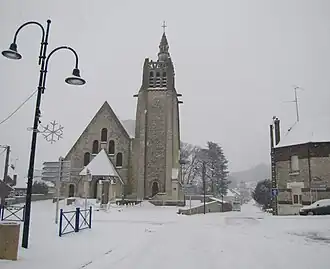 The church of Chavignon | |
 Coat of arms | |
Location of Chavignon | |
 Chavignon  Chavignon | |
| Coordinates: 49°28′47″N 3°31′19″E / 49.4797°N 3.5219°E | |
| Country | France |
| Region | Hauts-de-France |
| Department | Aisne |
| Arrondissement | Soissons |
| Canton | Fère-en-Tardenois |
| Intercommunality | Val de l'Aisne |
| Government | |
| • Mayor (2020–2026) | Catherine Bournonville[1] |
Area 1 | 11.55 km2 (4.46 sq mi) |
| Population (2022)[2] | 852 |
| • Density | 74/km2 (190/sq mi) |
| Time zone | UTC+01:00 (CET) |
| • Summer (DST) | UTC+02:00 (CEST) |
| INSEE/Postal code | 02174 /02000 |
| Elevation | 57–195 m (187–640 ft) (avg. 90 m or 300 ft) |
| 1 French Land Register data, which excludes lakes, ponds, glaciers > 1 km2 (0.386 sq mi or 247 acres) and river estuaries. | |
Chavignon (French pronunciation: [ʃaviɲɔ̃]) is a commune in the Aisne department in Hauts-de-France in northern France.
Geography
The river Ailette forms most of the commune's northern border.
Population
| Year | Pop. | ±% p.a. |
|---|---|---|
| 1968 | 584 | — |
| 1975 | 572 | −0.30% |
| 1982 | 629 | +1.37% |
| 1990 | 769 | +2.54% |
| 1999 | 793 | +0.34% |
| 2007 | 728 | −1.06% |
| 2012 | 787 | +1.57% |
| 2017 | 818 | +0.78% |
| Source: INSEE[3] | ||
See also
References
- ^ "Répertoire national des élus: les maires" (in French). data.gouv.fr, Plateforme ouverte des données publiques françaises. 13 September 2022.
- ^ "Populations de référence 2022" (in French). The National Institute of Statistics and Economic Studies. 19 December 2024.
- ^ Population en historique depuis 1968, INSEE
Wikimedia Commons has media related to Chavignon.