Montcornet, Aisne
Montcornet | |
|---|---|
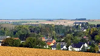 A general view of Chaourse and Montcornet | |
 Coat of arms | |
Location of Montcornet | |
 Montcornet  Montcornet | |
| Coordinates: 49°41′47″N 4°01′05″E / 49.6964°N 4.0181°E | |
| Country | France |
| Region | Hauts-de-France |
| Department | Aisne |
| Arrondissement | Vervins |
| Canton | Vervins |
| Intercommunality | Portes de la Thiérache |
| Government | |
| • Mayor (2020–2026) | Thomas Hennequin[1] |
Area 1 | 5.74 km2 (2.22 sq mi) |
| Population (2022)[2] | 1,224 |
| • Density | 210/km2 (550/sq mi) |
| Time zone | UTC+01:00 (CET) |
| • Summer (DST) | UTC+02:00 (CEST) |
| INSEE/Postal code | 02502 /02340 |
| Elevation | 108–177 m (354–581 ft) (avg. 112 m or 367 ft) |
| 1 French Land Register data, which excludes lakes, ponds, glaciers > 1 km2 (0.386 sq mi or 247 acres) and river estuaries. | |
Montcornet (French pronunciation: [mɔ̃kɔʁnɛ]) is a commune in the Aisne department in Hauts-de-France in northern France.
Battle of Montcornet
On 14 May 1940, Charles de Gaulle was given command of the new 4e Division cuirassée and ordered to execute a counterattack toward Montcornet, with the objective of slowing the German advance. This was one of the only counterattacks of the French campaign that succeeded in repulsing the German troops.
Population
| Year | Pop. | ±% |
|---|---|---|
| 1962 | 1,439 | — |
| 1968 | 1,486 | +3.3% |
| 1975 | 1,623 | +9.2% |
| 1982 | 1,781 | +9.7% |
| 1990 | 1,755 | −1.5% |
| 1999 | 1,690 | −3.7% |
| 2008 | 1,634 | −3.3% |
See also
References
- ^ "Répertoire national des élus: les maires" (in French). data.gouv.fr, Plateforme ouverte des données publiques françaises. 13 September 2022.
- ^ "Populations de référence 2022" (in French). The National Institute of Statistics and Economic Studies. 19 December 2024.
Wikimedia Commons has media related to Montcornet, Aisne.