Haution
Haution | |
|---|---|
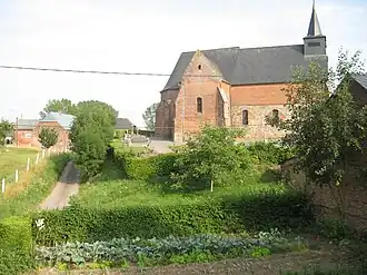 The church of Haution | |
Location of Haution | |
 Haution  Haution | |
| Coordinates: 49°52′02″N 3°50′28″E / 49.8672°N 3.8411°E | |
| Country | France |
| Region | Hauts-de-France |
| Department | Aisne |
| Arrondissement | Vervins |
| Canton | Vervins |
| Intercommunality | Thiérache du Centre |
| Government | |
| • Mayor (2020–2026) | Bernard Faucheux[1] |
Area 1 | 9.34 km2 (3.61 sq mi) |
| Population (2022)[2] | 130 |
| • Density | 14/km2 (36/sq mi) |
| Time zone | UTC+01:00 (CET) |
| • Summer (DST) | UTC+02:00 (CEST) |
| INSEE/Postal code | 02377 /02140 |
| Elevation | 130–199 m (427–653 ft) (avg. 127 m or 417 ft) |
| 1 French Land Register data, which excludes lakes, ponds, glaciers > 1 km2 (0.386 sq mi or 247 acres) and river estuaries. | |
Haution is a commune in the Aisne department in Hauts-de-France in northern France.
Population
| Year | Pop. | ±% p.a. |
|---|---|---|
| 1968 | 202 | — |
| 1975 | 157 | −3.54% |
| 1982 | 145 | −1.13% |
| 1990 | 184 | +3.02% |
| 1999 | 153 | −2.03% |
| 2009 | 146 | −0.47% |
| 2014 | 152 | +0.81% |
| 2020 | 133 | −2.20% |
| Source: INSEE[3] | ||
See also
References
- ^ "Répertoire national des élus: les maires" (in French). data.gouv.fr, Plateforme ouverte des données publiques françaises. 4 May 2022.
- ^ "Populations de référence 2022" (in French). The National Institute of Statistics and Economic Studies. 19 December 2024.
- ^ Population en historique depuis 1968, INSEE
Wikimedia Commons has media related to Haution.