Děkanovice
Děkanovice | |
|---|---|
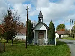 Centre of Děkanovice with a chapel | |
 Flag  Coat of arms | |
 Děkanovice Location in the Czech Republic | |
| Coordinates: 49°37′7″N 15°8′55″E / 49.61861°N 15.14861°E | |
| Country | |
| Region | Central Bohemian |
| District | Benešov |
| First mentioned | 1352 |
| Area | |
• Total | 4.08 km2 (1.58 sq mi) |
| Elevation | 470 m (1,540 ft) |
| Population (2025-01-01)[1] | |
• Total | 62 |
| • Density | 15/km2 (39/sq mi) |
| Time zone | UTC+1 (CET) |
| • Summer (DST) | UTC+2 (CEST) |
| Postal code | 257 68 |
| Website | www |
Děkanovice is a municipality and village in Benešov District in the Central Bohemian Region of the Czech Republic. It has about 60 inhabitants.
Demographics
| Year | Pop. | ±% |
|---|---|---|
| 1869 | 177 | — |
| 1880 | 167 | −5.6% |
| 1890 | 152 | −9.0% |
| 1900 | 158 | +3.9% |
| 1910 | 185 | +17.1% |
| 1921 | 182 | −1.6% |
| 1930 | 166 | −8.8% |
| 1950 | 135 | −18.7% |
| 1961 | 144 | +6.7% |
| 1970 | 132 | −8.3% |
| 1980 | 102 | −22.7% |
| 1991 | 83 | −18.6% |
| 2001 | 64 | −22.9% |
| 2011 | 59 | −7.8% |
| 2021 | 59 | +0.0% |
| Source: Censuses[2][3] | ||
References
- ^ "Population of Municipalities – 1 January 2025". Czech Statistical Office. 2025-05-16.
- ^ "Historický lexikon obcí České republiky 1869–2011" (in Czech). Czech Statistical Office. 2015-12-21.
- ^ "Population Census 2021: Population by sex". Public Database. Czech Statistical Office. 2021-03-27.
External links
Wikimedia Commons has media related to Děkanovice.