Freienorla
Freienorla | |
|---|---|
Location of Freienorla within Saale-Holzland-Kreis district 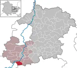 | |
 Freienorla  Freienorla | |
| Coordinates: 50°46′10″N 11°32′34″E / 50.76944°N 11.54278°E | |
| Country | Germany |
| State | Thuringia |
| District | Saale-Holzland-Kreis |
| Municipal assoc. | Südliches Saaletal |
| Government | |
| • Mayor (2022–28) | Runa Partschefeld[1] |
| Area | |
• Total | 6.81 km2 (2.63 sq mi) |
| Elevation | 180 m (590 ft) |
| Population (2024-12-31)[2] | |
• Total | 310 |
| • Density | 46/km2 (120/sq mi) |
| Time zone | UTC+01:00 (CET) |
| • Summer (DST) | UTC+02:00 (CEST) |
| Postal codes | 07768 |
| Dialling codes | 036423 |
| Vehicle registration | SHK, EIS, SRO |
| Website | www.freienorla.de |
Freienorla is located in the German state of Thuringia. Although quite small and obscure, the municipality is known locally for its Gothic church as well as its lower mill, a watermill facility thought to be built in the tenth century. The Orlabahn railroad has a station located in Freienorla. Neighboring towns include Jena and Eisenberg. Freienorla is located 145 miles from the capital of Berlin.
-
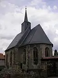 Gothic church
 -
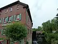 Lower mill
References
- ^ Gewählte Bürgermeister - aktuelle Landesübersicht, Freistaat Thüringen, accessed 10 November 2022.
- ^ "Bevölkerung der Gemeinden vom Thüringer Landesamt für Statistik" (in German). Thüringer Landesamt für Statistik.
External links