Weißenborn, Thuringia
Weißenborn | |
|---|---|
Location of Weißenborn within Saale-Holzland-Kreis district 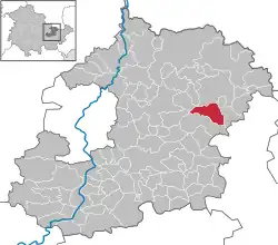 | |
 Weißenborn  Weißenborn | |
| Coordinates: 50°55′18″N 11°52′50″E / 50.92167°N 11.88056°E | |
| Country | Germany |
| State | Thuringia |
| District | Saale-Holzland-Kreis |
| Municipal assoc. | Bad Klosterlausnitz |
| Government | |
| • Mayor (2020–26) | Christiane Putzer[1] |
| Area | |
• Total | 10.04 km2 (3.88 sq mi) |
| Elevation | 342 m (1,122 ft) |
| Population (2024-12-31)[2] | |
• Total | 1,126 |
| • Density | 110/km2 (290/sq mi) |
| Time zone | UTC+01:00 (CET) |
| • Summer (DST) | UTC+02:00 (CEST) |
| Postal codes | 07639 |
| Dialling codes | 036601 |
| Vehicle registration | SHK, EIS, SRO |
| Website | www.weissenborn-thueringen.de |
Weißenborn is a municipality in the district Saale-Holzland, in Thuringia, Germany. It is located near the A4 and A9 Motorways.
References
- ^ Gewählte Bürgermeister - aktuelle Landesübersicht, Freistaat Thüringen, accessed 14 July 2021.
- ^ "Bevölkerung der Gemeinden vom Thüringer Landesamt für Statistik" (in German). Thüringer Landesamt für Statistik.