Weißbach, Thuringia
Weißbach | |
|---|---|
Location of Weißbach within Saale-Holzland-Kreis district 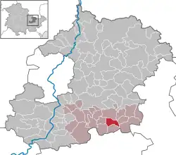 | |
 Weißbach  Weißbach | |
| Coordinates: 50°48′46″N 11°47′20″E / 50.81278°N 11.78889°E | |
| Country | Germany |
| State | Thuringia |
| District | Saale-Holzland-Kreis |
| Municipal assoc. | Hügelland-Täler |
| Government | |
| • Mayor (2022–28) | Walther Kahlert[1] |
| Area | |
• Total | 5.29 km2 (2.04 sq mi) |
| Elevation | 240 m (790 ft) |
| Population (2024-12-31)[2] | |
• Total | 128 |
| • Density | 24/km2 (63/sq mi) |
| Time zone | UTC+01:00 (CET) |
| • Summer (DST) | UTC+02:00 (CEST) |
| Postal codes | 07646 |
| Dialling codes | 036426 |
| Vehicle registration | SHK, EIS, SRO |
| Website | www.huegelland-taeler.de |
Weißbach (German pronunciation: [ˈvaɪsbax]) is a municipality in the district Saale-Holzland, in Thuringia, Germany. The name of the location was vouched first about 1400,[3] according to other sources in 1072.[4] Meat production is dominating in local business.
References
- ^ Gewählte Bürgermeister - aktuelle Landesübersicht, Freistaat Thüringen, accessed 10 November 2022.
- ^ "Bevölkerung der Gemeinden vom Thüringer Landesamt für Statistik" (in German). Thüringer Landesamt für Statistik.
- ^ Wolfgang Kahl, Ersterwähnung Thüringer Städte und Dörfer, Bad Langensalza, 2010, ISBN 978-3-86777-202-0, p. 307
- ^ "Home". huegelland-taeler.de.